Logo Turismo Granada Header

Vía Directa – Madrileños – Superdirecta de la Norte de la Alcazaba

Ascent of the Alcazaba (3,371 masl.) under winter conditions and combining the Vias Directa, de los Madrileños and Superdirecta on its north face.

Downloads

Alta Montaña

High Mountain

Alpinismo

Alpinism

Invierno

Winter, Spring

Technical data sheet

Technical Difficulty:

Very demanding activity, with a very important distance and slopes, and to be developed under winter conditions. Rock climbing up to IVº+, snow slopes close to 50º and ice projections of 85º (AD sup, 525 m., IVº+, 50th, WI4). Before starting the route, in addition to the weather conditions (snow, rain, wind...), the risk of avalanches and the unusual presence of ice must be taken into account (consult it here).

Equipment:

Self-protection routes (classic climbing and mountaineering).

Details on the duration:

45:55 pm. (2 days approximately).

Time without stops: 12:20 pm.
Distance: 32,60 Km.
Positive height gain accumulated: Of 2,973,00 m.
Negative height gain accumulated: Of 2,973,00 m.
Minimum altitude: 1.154,00 m.
Maximum altitude: 3.371,00 m.
Departure point: Vegueta del Caracol, Güéjar-Sierra.
Point of arrival: Vegueta del Caracol, Güéjar-Sierra.
Water points: Yes.
List of water points:

Since this is an itinerary to be done under winter conditions, the water available from 2,000-2,500 m. will be mostly in the form of snow. That is why it is necessary to carry a stove and gas cartridge (in order to melt the snow), as well as a supplement of mineral salts and vitamins to add to the melted water. Below the mentioned elevation we will find running water in most of the ravines that the Vereda de la Estrella crosses, in the Guarnón River (point 3), in the Valdeinfierno River (the section between points 4 and 5), and in the Valdecasillas River (point 7).

Closest/s Population/s : Güéjar-Sierra, Pradollano, Capileira and Trevélez.
Municipality/ies: Güéjar-Sierra, and Trevelez.
Region/s: Vega de Granada and the Alpujarra of granada.
Natural Space/s: Natural park of Sierra Nevada - Las Alpujarras

Map & Profile

Mapa-Directa-Madrilenos-Norte-Alcazaba-Web
Map "Vía Directa – Madrileños – Superdirecta de la Norte de la Alcazaba"
Profile of the route "Vía Directa – Madrileños – Superdirecta de la Norte de la Alcazaba"

Full tour

Total distance: 34026 m

Day 1

Total distance: 12712 m

Day 2

Total distance: 8419 m

Day 3

Total distance: 12711 m

Waypoints

Point Name Time (*) Height Latitude (**) Length (**)
0 Vegueta del Caracol (parking) 0:00 h.
(day 1)
1.175 m. N37° 08' 06.3" W3° 23' 20.5"
1 Castaño El Abuelo 0:45 h.
(day 1)
1260 m. N37° 07' 53.6" W3° 22' 11.6"
2 Viso de las Nortes 1:30 pm.
(day 1)
1.390 m. N37° 07' 40.8" W3° 21' 01.0"
3 River Guarnón 2:30 h.
(day 1)
1.490 m. N37° 06' 32.2" W3° 20' 27.3"
4 Junta de los Ríos 3:10 h.
(day 1)
1,667. N37° 05' 44.8" W3° 19' 34.6"
5 Zona de Cueva Secreta 3:30 pm.
(day 1)
1.742 m. N37° 05' 32.2" W3° 19' 37.5"
6 Loma de Casillas 4:30 pm.
(day 1)
1.968 m. N37° 05' 16.0" W3° 19' 21.8"
7 River Valdecasillas (nights) 5:45 pm.
(day 1)
2.087 m. N37° 04' 45.1" W3° 19' 13.8"
7 River Valdecasillas (nights) 0:00 h.
(day 2)
2.087 m. N37° 04' 45.1" W3° 19' 13.8"
8 Espolón de la Alcazaba 1:20 h.
(day 2)
2.283 m. N37° 04' 56.6" W3° 18' 51.7"
9 Abandonment of the Espolón de la Alcazaba 3:10 h.
(day 2)
2.649 m. N37° 04' 34.7" W3° 18' 25.8"
10 Start of the vía Directa route up the north face of the Alcazaba 4:50 pm.
(day 2)
2.846 m. N37° 04' 22.9" W3° 18' 10.0”
11 Alcazaba 6:40 pm.
(day 2)
3.371 m. N37° 04' 08.7" W3° 18' 00.0"
12 Beginning of the downhill corridor on the west face 7:30 pm.
(day 2)
3.301 m. N37° 04' 00.7" W3° 18' 04.4"
13 Laguna de la Mosca or the Mulhacén 9:00 h.
(day 2)
2,900 m. N37° 03' 37.8" W3° 18' 50.3"
7 River Valdecasillas (nights) 11:45 h.
(day 2)
2.087 m. N37° 04' 45.1" W3° 19' 13.8"
7 River Valdecasillas (nights) 0:00 h.
(day 3)
2.087 m. N37° 04' 45.1" W3° 19' 13.8"
6 Loma de Casillas 0:20 h.
(day 3)
1.968 m. N37° 05' 16.0" W3° 19' 21.8"
5 Zona de Cueva Secreta 0:35 h.
(day 3)
1.742 m. N37° 05' 32.2" W3° 19' 37.5"
4 Junta de los Ríos 0:50 h.
(day 3)
1,667. N37° 05' 44.8" W3° 19' 34.6"
3 River Guarnón 1:45 h.
(day 3)
1.490 m. N37° 06' 32.2" W3° 20' 27.3"
2 Viso de las Nortes 2:35 h.
(day 3)
1.390 m. N37° 07' 40.8" W3° 21' 01.0"
1 Castaño El Abuelo 3:25 pm.
(day 3)
1260 m. N37° 07' 53.6" W3° 22' 11.6"
0 Vegueta del Caracol (parking) 4:10 h.
(day 3)
1.175 m. N37° 08' 06.3" W3° 23' 20.5"

(*) Approximate times counting stops.
(**) Geographic coordinates. European Datum 1950.

Videocover-Directa-Madrilenos-Norte-Alcazaba
Play Video

Introduction

Much of the information reflected in this review has been obtained from the Guía de Escaladas de Sierra Nevada, a work by Antonio José Herrera published by Nevadensis, S.L. Alfonso Cordero Álvarez has contributed many of the photographs shown here.

The proposed activity takes place over three days, specifically, during one afternoon, one day and one morning, which requires an overnight stay of two nights in the mountain. The approach to the climbing route starts at Vegueta del Caracol and runs along the Vereda de la Estrella. After reaching the area of Cueva Secreta, we "skip" the Loma de Casillas and reach the Valdecasillas River, where we bivouac for the first night. The next day, leaving early in the morning, we reach the north wall of the Alcazaba and climb to its summit following a combination of the Directa, los Madrileños and Superdirecta routes. Once the summit of the Alcazaba is reached, we descend from it through its west face, passing then through the Laguna de la Mosca and returning to the bivouac site, located next to the Valdecasillas River, where we spend a second night. During the morning of the third day we return to the Vegueta del Caracol.

The Alcazaba is, for many mountaineers, the most beautiful summit of Sierra Nevada. Its north face is considered the most alpine of all the existing walls in the massif.

Description

DURATION:

The proposed activity requires 1 evening, 1 day and 1 morning. Consequently, it is necessary to bivouac for two consecutive nights.

DIFFICULTY:

Very high. The realization of the route requires bivouacking for 2 nights and the use of climbing equipment, which entails carrying a large backpack, weighing about 15-18 kg. It is a demanding excursion, with 2,978 m. of positive and 2,978 m. of negative height gain. The total distance to be covered is 32.6 km. During the route it is necessary to climb up to IVº+ on rock, to climb snowy slopes close to 50º and to climb on ice with an inclination of up to 85º. It is essential to master progression with crampons and ice axes, as well as the various techniques associated with classic climbing on snow, rock, ice and mixed terrain (double rope, self-protection...). Some of the members of the group must know how to orient themselves without traces as well as navigate with GPS (essential due to the high probability of encountering fog on the route). We must never overestimate our capabilities. In case of doubt, please contact a mountain guide.

M. I. D. E. Method (tour Information):

Assessment of aspects 1 to 5.

WATER:

Since this is an itinerary to be done under winter conditions, the water available from 2,000-2,500 m. will be mostly in the form of snow. That is why it is necessary to carry a stove and gas cartridge (in order to melt the snow), as well as a supplement of mineral salts and vitamins to add to the melted water. Below the mentioned elevation we will find running water in most of the ravines that the Vereda de la Estrella crosses, in the Guarnón River (point 3), in the Valdeinfierno River (the section between points 4 and 5), and in the Valdecasillas River (point 7).

MATERIAL NEEDED:

Individual (generic): Rigid or semi-rigid hiking boots, warm clothing (hat, two pairs of gloves, fleece or similar, windbreaker...), waterproof jacket, neck tube, sunglasses (also a second spare pair or blizzard goggles), sunscreen and high protection lipstick, walking sticks, head flashlight, pocket knife, lighter, cell phone (with spare charge), large backpack (70-80 l.), water (1.5-2 l.), food for 3 days, kitchen utensils (cup, plate, cutlery...), T-shirts, underwear and socks, and leggings. ), water (1.5-2 l.), food for 3 days, kitchen utensils (cup, plate, cutlery...), spare T-shirts, underwear and socks, and gaiters.

Individual to bivouac: mat and sleeping bag.

Solo climbing: helmet, crampons, two ice axes (technical or semi-technical), harness, two locking biner, descender, rope ring (for self-locking knot) and lanyard (e.g. locking biner and dynamic rope).

Collective (generic, for a team of 2-3 people): first aid kit, map, compass, GPS (with spare charge), stove, gas cartridge and saucepan or similar for melting snow and cooking.

Collective for camping night (for two teams of 2-3 people): 3-season tent.

Collective for rock climbing (for two teams of 2-3 people):

Two 60 m. double ropes, 2-3 ice screws, 1 stake, 1 anchor, assorted belay devices (4-5 medium and small friends and 6-7 small crackers), 5-6 extra-flat non-deformable (hard) steel pitons, 12 sewn lanyards (10 of 60 cm. and 2 of 120 cm.) with their respective pairs of carabiners, and 6 locking biners and 2 sewn lanyards of 180 cm. for equalized anchor systems.

BEST TIME/S:

The recommended season to make this route runs from early December until mid-April, when the snow covers the mountains. Attention to the possible rockfall and avalanches in the spring if it drains too much of the season.

MAPPING:

  • Sierra Nevada National park. The Alpujarra. Marquesado del Zenete. Scale 1:40.000. Editorial Penibética.
  • Topographic map of Slopes of the Sierra Nevada (Evaluator Risk of Avalanches). Scale 1:25,000. Editorial Vane.

LANDSCAPE:

High siliceous summits with glacial and periglacial forms.

PEAKS/PORTS:

Ascent to the Alcazaba (3.371 m.).

MATCHING ALTERNATIVE ACTIVITIES:

Among the alternative activities nearby, and with similar characteristics, we highlight the ascent to the Alcazaba under winter conditions and following its North Corridor.

REMARKS:

The descent to be made on the climbing day, the one proposed through the west face of the Alcazaba, and then next to and below the Chorreras de la Mosca, is the most advisable of the possible descents when conditions are good (good weather, no ice and little or no risk of avalanches). Even so, the descent is dangerous because, in both places, there are very close vertical walls below.

If necessary, once we reach the top of the Alcazaba, we could descend through the Cañada de los Borregos (a wide watercourse located south of the summit), and, going around the Peñón del Globo (to the east), descend to the Cañada de Siete Lagunas. Once located in the place where the Laguna Hondera (Chorreras Negras) drains, we will continue down, soon locating the path that takes us to Revele. In that way, at 1:30 h. approximate walk from the Laguna Hondera, we will find the Refugio de la Campiñuela, which could serve as shelter.

RULES TO RESPECT:

Summarized in a brief guide to environmental regulations applied to mountain sports in protected natural spaces of Andalusia (pages 52 and 53) and in the booklets General rules in the Natural area of Sierra Nevada, Responsible behavior in the National Park and Natural Park of Sierra Nevada, and Responsible behavior, Droppings, and debris of personal hygiene. More extended in the Decree 238/2011, 12 July, which establishes the organization and management of Sierra Nevada (points 5.4.5. –p. 163 - and 5.2. –page 262-). In addition, the realization of this activity, as it involves overnight camping, requires prior authorization or notification (depending on the number of participants and tents). Applications can be obtained through the following address: pnsierranevada.usopublico.dtgr.capds@juntadeandalucia.es

WEATHER:

ROAD CONDITIONS:

Before starting the route, it is recommended to check the conditions of the mountain range (risk of avalanches, presence of ice...) through the following links:

How to arrive by car

From Granada we exit through the A-44 in the direction of Motril and take the exit 132 (Ronda Sur/Sierra Nevada/Alhambra/Campus de la Salud/Armilla). Once in Ronda Sur, we take the exit 5B (A-395/Sierra Nevada/Pinos Genil). Follow the road A-395 to take the exit “Cenes de la Vega/Pinos Genil/Güéjar-Sierra/Dúdar/Quéntar”, and, now in the A-4026 we will follow the signs until we reach Pinos Genil. Immediately after you enter Pinos Genil, take the detour to Güéjar-Sierra following the road GR-3200. Past the Embalse de Canales we will have reached the village of Güéjar-Sierra, will have to cross it following the Calle Hermanas Quirós and Camino Desvino (according to the indications that indicate the way to follow towards the "Valle del Genil") and, finally, the Carretera de Maitena (towards "Maitena/Charcón" first, and, later, "Río Maitena"). After crossing the Maitena River through a bridge, we will follow the asphalted road that, thanks to several tunnels and bridges (through which the old Tramway of the Sierra used to run) will lead us to the Vegueta del Caracol (point 0), where we find our parking.

Parking

Available.
Parking exit:

Vegueta del Caracol, Güéjar-Sierra.
https://goo.gl/maps/J15X1uihA13mRQKT9

Parking arrival:

Vegueta del Caracol, Güéjar-Sierra.
https://goo.gl/maps/J15X1uihA13mRQKT9

How to get there by public transport

The buses in the direction of Güéjar-Sierra depart from the bus stop in Granada which do it at different hours. Once we arrive by bus to bus stop Güéjar-Sierra, you can use the public transportation services available for one of them to take us to the Vegueta del Caracol (point 0). We will have to arrange with the transport company to pick us up at Vegueta del Caracol and take us to the bus stop in Güéjar-Sierra once the route is finished. Buses leaving from Güéjar-Sierra to Granada leave at different hours.

Route

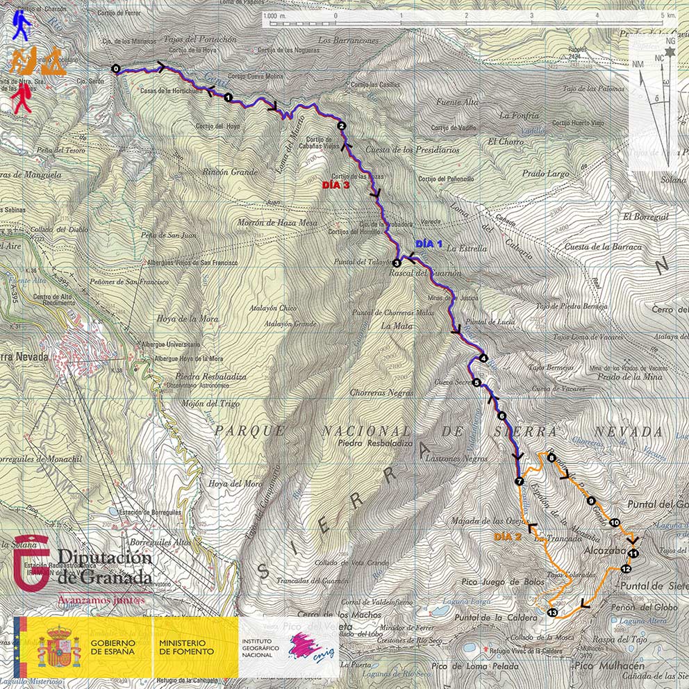
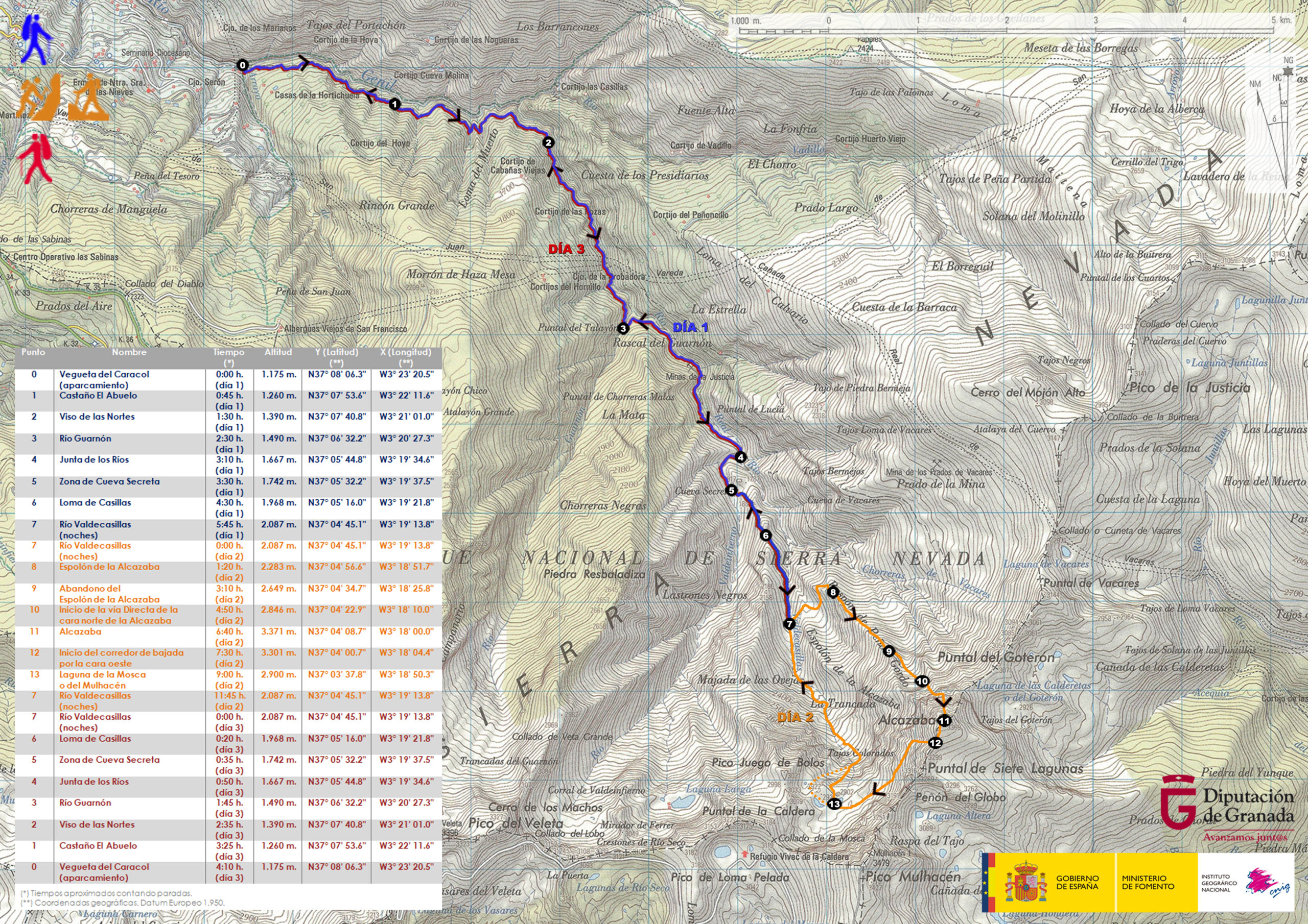
DAY 1: VEGUETA DEL CARACOL – RIVER VALDECASILLAS


The path starts in the Vegueta del Caracol (point 0), place where the Arroyo de San Juan flows into the Genil River, and where the route of the Tramway of the Sierra used to arrive in the past. We will cross the Genil River over a bridge and join the Vereda de la Estrella.

The Vereda de la Estrella was opened in the 60's of the XIX century to facilitate the access of people and the transport of materials to and from the mines of La Probadora, La Estrella and La Justicia, all of them located upstream of the Genil River.

In the first part of our tour we will observe how the Vereda de la Estrella runs over deep gorges. This is the area of the Arrecife. Soon after, we will pass by the chestnut tree El Abuelo (point 1), an ancient specimen known by that name among the mountaineers.

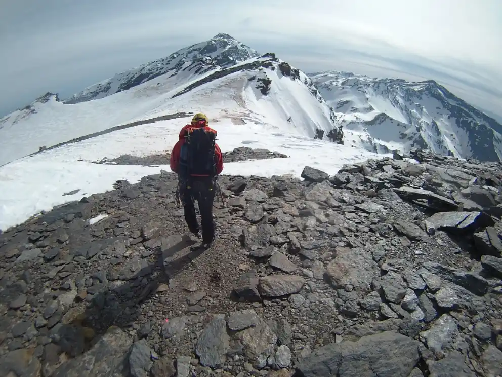
Following the Vereda de la Estrella we will cross the Barrancos de las Tormentas, de la Loma del Muerto and de Cabañas Viejas. We will travel at all times along the left bank of the Genil (orographically speaking), and it will be, when we turn decisively to the south, when the imposing north faces of the Alcazaba and the Mulhacén will appear in the background and over the valley. At that precise moment, we will find ourselves in the known as Curva del Viso, or Viso de las Nortes (point 2).

Continuing our approach along the trail, we will pass by the Minas de la Probadora. Soon, we will arrive at the crossroads where the path that comes from the Cortijo del Hornillo joins the Vereda de la Estrella. We will continue straight on, ignoring the detour, and we will cross the remains of the old settlement that once constituted the Minas de la Estrella. We will go down to the Guarnón River, which flows into the Genil River just below the Minas de las Estrella, and we will cross it thanks to a bridge (point 3).

Once we cross the Guarnón River, we will go around the Loma del Lanchar, we will contemplate the Barranco del Aceral, whose waters fall into the Genil River like a waterfall, and soon we will arrive at the Minas de la Justicia.

After passing the remains of the Minas de la Justicia, we will arrive at the Junta de los Rios (point 4), a place where the rivers Valdecasillas and Valdeinfierno unite to form the River Genil.

Pared Norte de la Alcazaba vista desde las proximidades de la Junta de los Ríos (punto 4), al atardecer
North wall of the Alcazaba as viewed from the vicinity
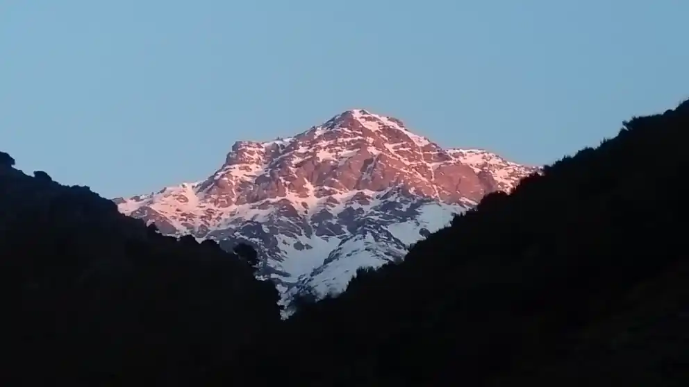
the Junta de los Ríos (point 4), at sunset

We will follow the course of the Valdeinfierno River through the Majada del Real and reach the area known as Cueva Secreta (point 5). After crossing the Valdeinfierno River thanks to a bridge, and placing ourselves on the Majada del Palo, we will go diagonally up the western slope of the Loma de Casillas until we surpass it (point 6).

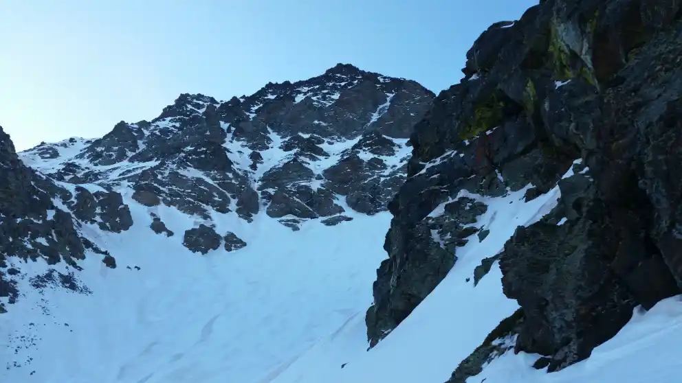
Once we have crossed the Loma de Casillas, we will have entered the Valdecasillas River valley. We will contemplate the entire Espolón de la Alcazaba, a huge scrape, rather hill in its lower half, 1,500 meters of unevenness and that constitutes the hinge that separates the north face of the west face of the Alcazaba. Given that the next day we will begin ascending the Espolón de la Alcazaba, we will head towards the Valdecasillas River, we will continue ascending briefly next to it, and, in the proximity of its waters, we will look for the best of the stone corrals to bivouac (point 7).

DAY 2: RIVER VALDECASILLAS – NORTH OF THE ALCAZABA – RIVER VALDECASILLAS

On the second day we will leave from our place of overnight stay (point 7) at about 04:00-05:00 h. Previously, we will have hidden our bivouac material.

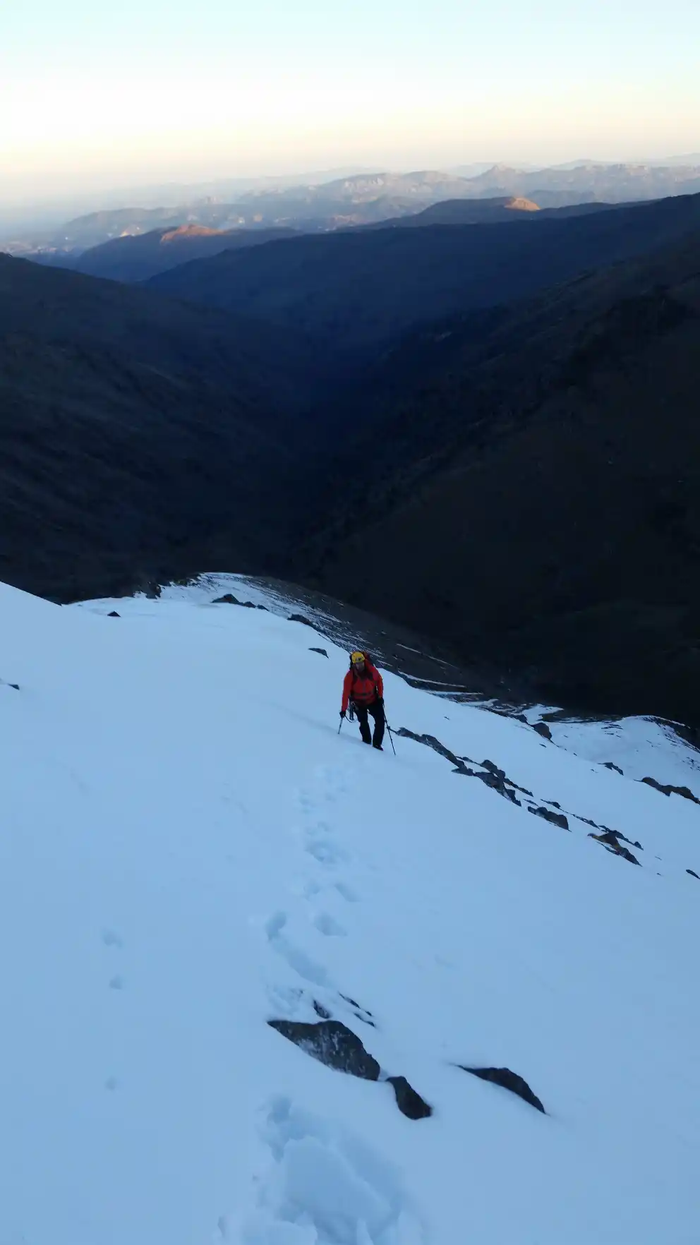
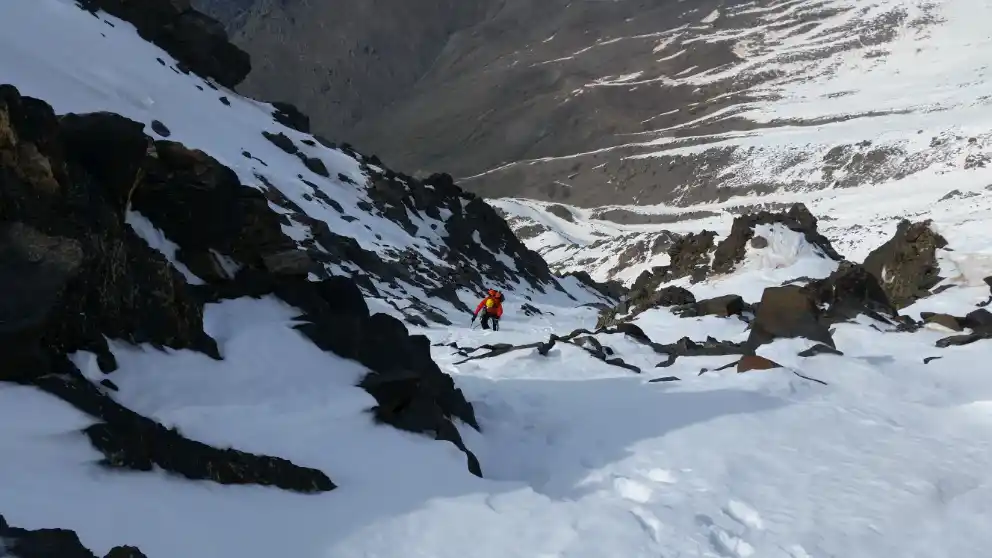
We will start going up the opposite slope of the river. To do this we will cross it and follow one of the traces that, diagonally, and in a northeastern direction, will allow us to overcome the slope and reach the edge of a marked watercourse. We will cross the flat valley, in an eastward direction, and we will go up again. We will find ourselves already on the western slope of the Espolón de la Alcazaba, but we will not find any trace to follow. What we will do is to always climb diagonally, in a northern direction, avoiding the natural obstacles that we will find (small rocky projections and bushy vegetation) until we reach the edge of a new watercourse, this one steeper than the previous one and that we will not cross, but we will go up until we are at the beginning of the Espolón de la Alcazaba, on which we will find a prominent rock (point 8).

From this place we will have to go up the hill that is here the Espolón de la Alcazaba until we reach 2,650 meters above sea level (point 9), when we will leave the spur to go to the left, halfway up the slope, and enter the hanging funnel-shaped valley that is located in the right half of the north face of the Alcazaba, just below the north wall itself.

Subiendo el Espolón de la Alcazaba
Climbing the Espolón de la Alcazaba

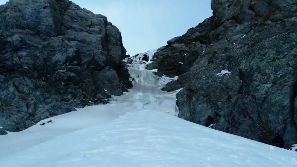
Once we have entered the hanging valley, we will have to head towards its upper left end, where the access to the narrow corridor that constitutes the beginning of the Vía Directa of the North of the Alcazaba is located (point 10).

Vista de la vía de escalada desde la entrada al valle colgado
View of the climbing route from the entrance to the hanging valley.

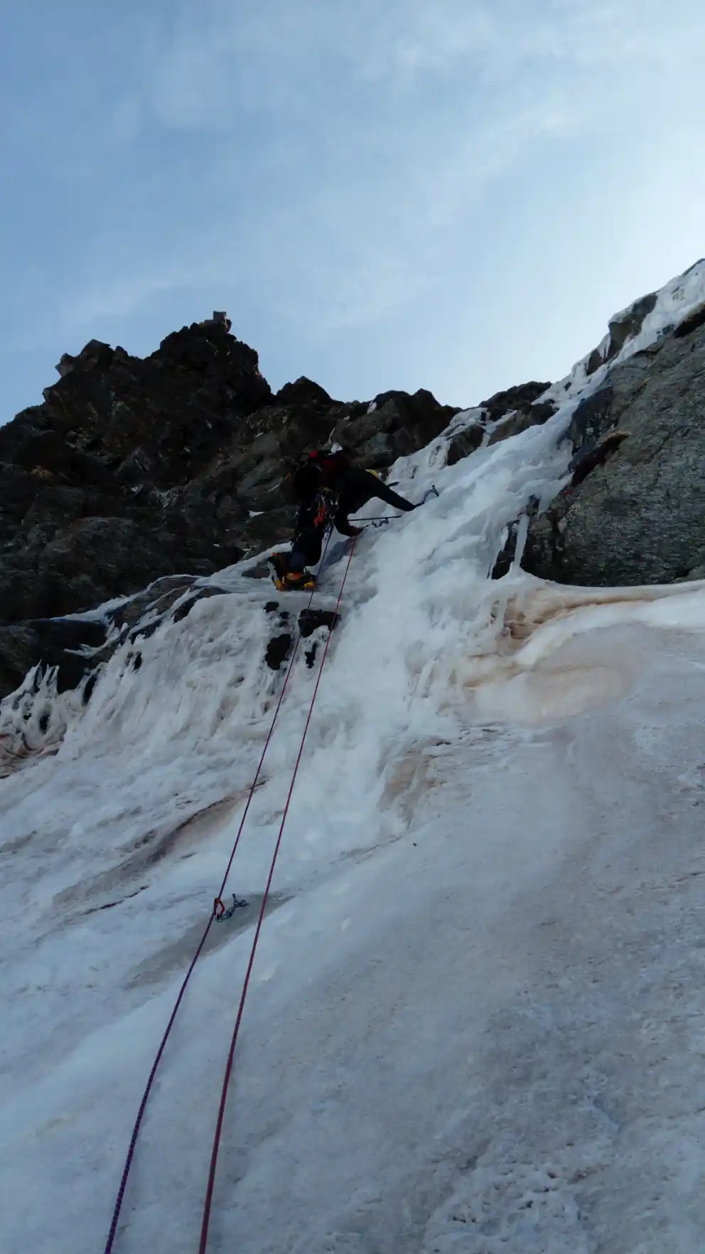
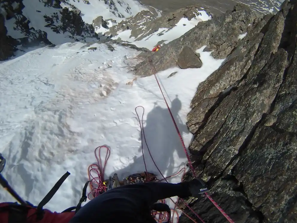
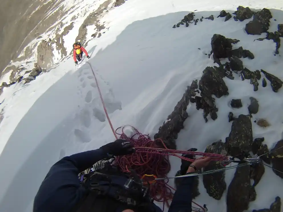
The initial corridor presents an ice cascade with a short section of inclination close to 85º. This waterfall can be surmounted in 2 pitches of rope by mounting meetings on rock. Once the waterfall is overcome, a third pitch of mixed climbing will allow us to access the icefall that, located under the Gran Vasar de la Alcazaba, we will climb.

Corredor helado inicial
Initial ice corridor
Inicio del corredor (punto 10)
Start of the corridor (item 10)
Durante la escalada del corredor inicial
During the initial corridor climb
Durante la escalada del corredor inicial
During the initial corridor climb
Largo en mixto a la salida del corredor inicial
Mixed pitch at the start of the initial corridor

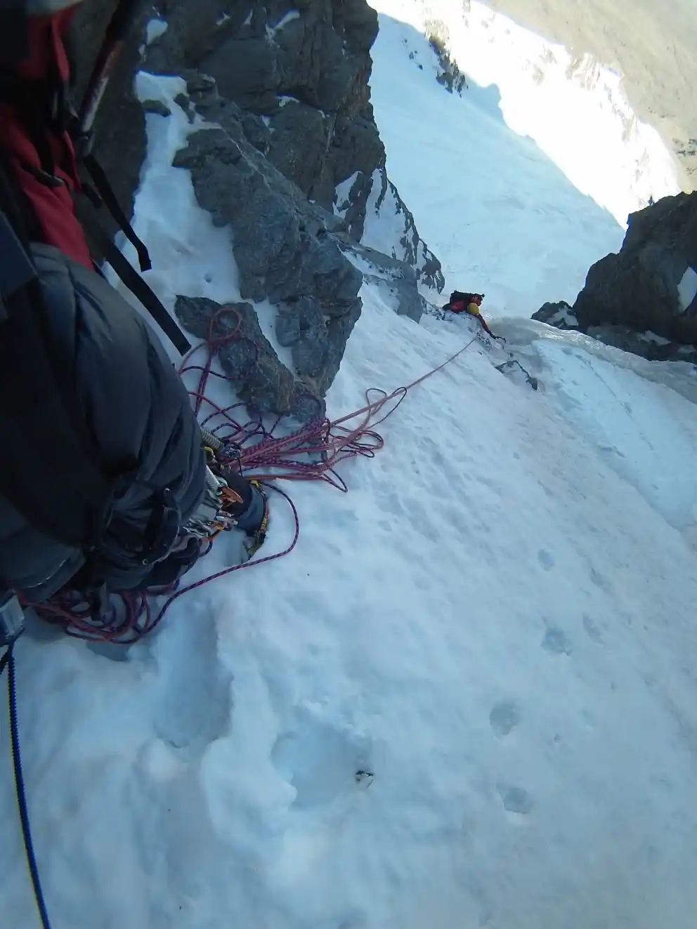
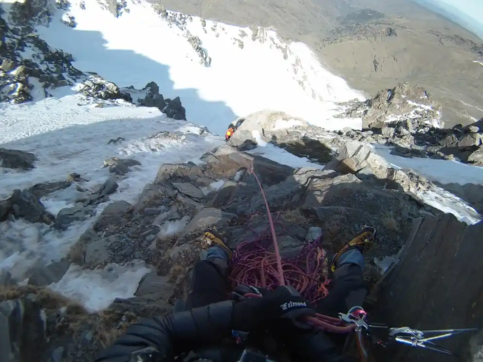
The Gran Vasar is a cornice located at 3,000 m.a.s.l. that runs horizontally along both the north and west faces of the Alcazaba, being widely used by mountaineers to move across it in summer.

When we finish climbing the snowdrift, once we are on the Gran Vasar, we will have to continue ascending through the obvious corridor that, starting diagonally to the left, avoids the vertical wall above us. By following this second corridor we leave the Via Directa to continue along the Via de los Madrileños of the Northern face of the Alcazaba.

Ascendiendo el segundo corredor
Ascending to the second broker

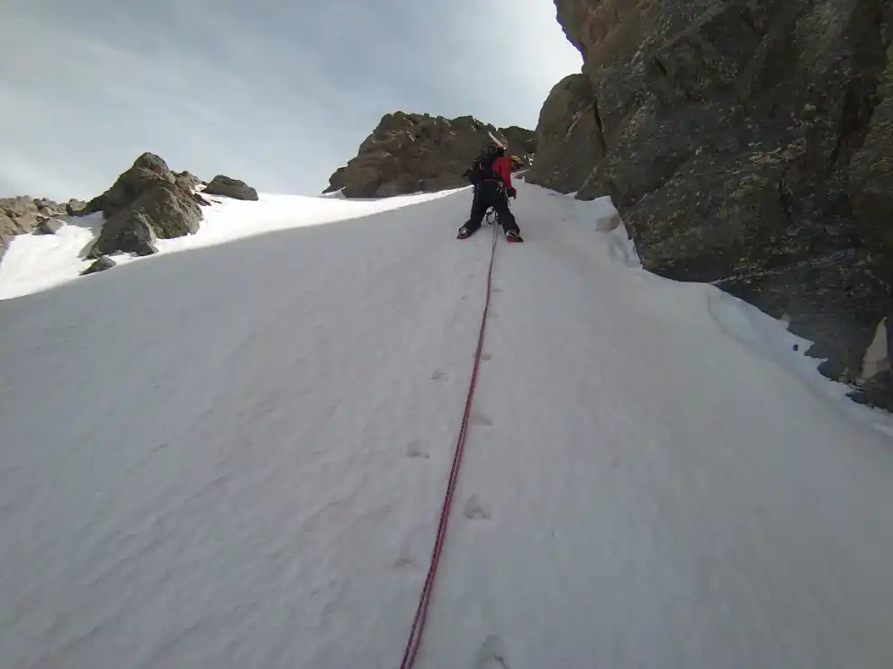
At the end of the corridor, we will turn to the right and we will come across a ledge that, if overcome from the left, will be rocky and will present a difficulty of IVº+.

Superando el resalte de roca situado al final del segundo corredor
Overcoming the rocky ledge situated at the end of the second corridor

After overcoming this difficulty, we will alternate the ascent through snow slopes with some rocky projections (IIIº+).

Resalte de roca
Rocky ledge
Nevero sobre resalte de roca
Frost on rock ledge
Pendiente de nieve
Slope of snow

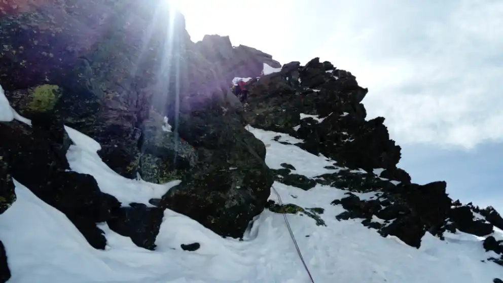
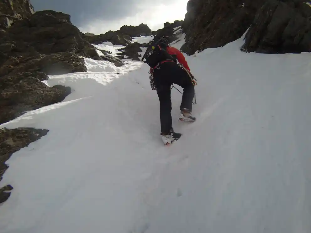
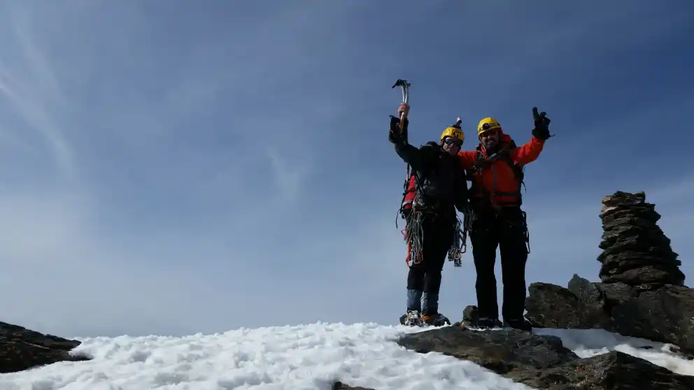
Finally, we will find ourselves situated on the snow slopes that will take us to the summit of the Alcazaba (point 11). This final part of the climb coincides with the Via Superdirecta of the North Alcazaba.

Pendientes finales
Pending end
Cumbre de la Alcazaba
Summit of the Alcazaba

The descent from the top of the Alcazaba will be made through an obvious corridor located on the west face and whose beginning (point 12) is very close to the summit.

Hacia el inicio del corredor de bajada. El Mulhacén al fondo.
Towards the beginning of the corridor on the way down. The Mulhacén in the background.
Inicio del corredor de bajada
Start of the corridor down

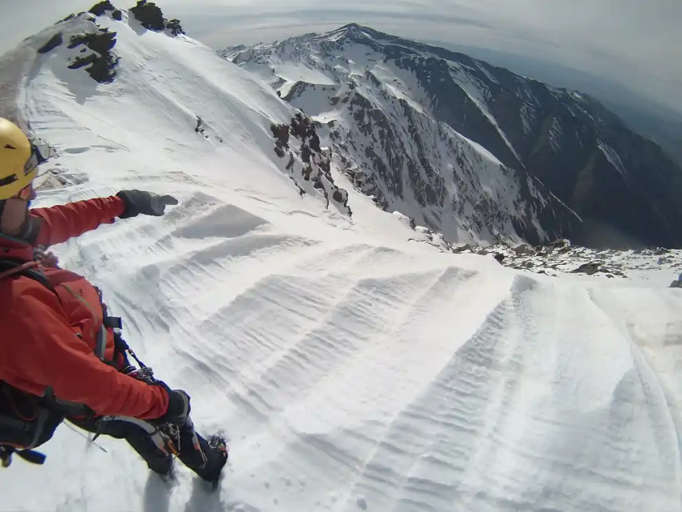
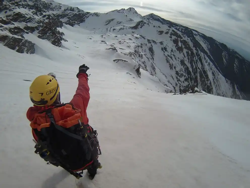
Once we have descended this corridor, we will be on the great snow that crosses the west face of the Alcazaba. We will follow the snow to the left, in gradual descent, directing our steps towards the Hoya del Mulhacén, where the Laguna de la Mosca is located (point 13), which may be completely hidden under the snow.

Final del corredor de bajada y comienzo del nevero a seguir hacia la Laguna de la Mosca
End of the downhill corridor and beginning of the snowfield to follow
towards the Laguna de la Mosca.
Hacia la Laguna de la Mosca. Posibilidades de descenso hacia el Valdecasillas  (la que se ve a la derecha es la más aconsejable, por menos peligrosa)
Towards the Laguna de la Mosca. Possibilities of descent towards the Valdecasillas
(the one seen on the right is the most advisable, for less dangerous).

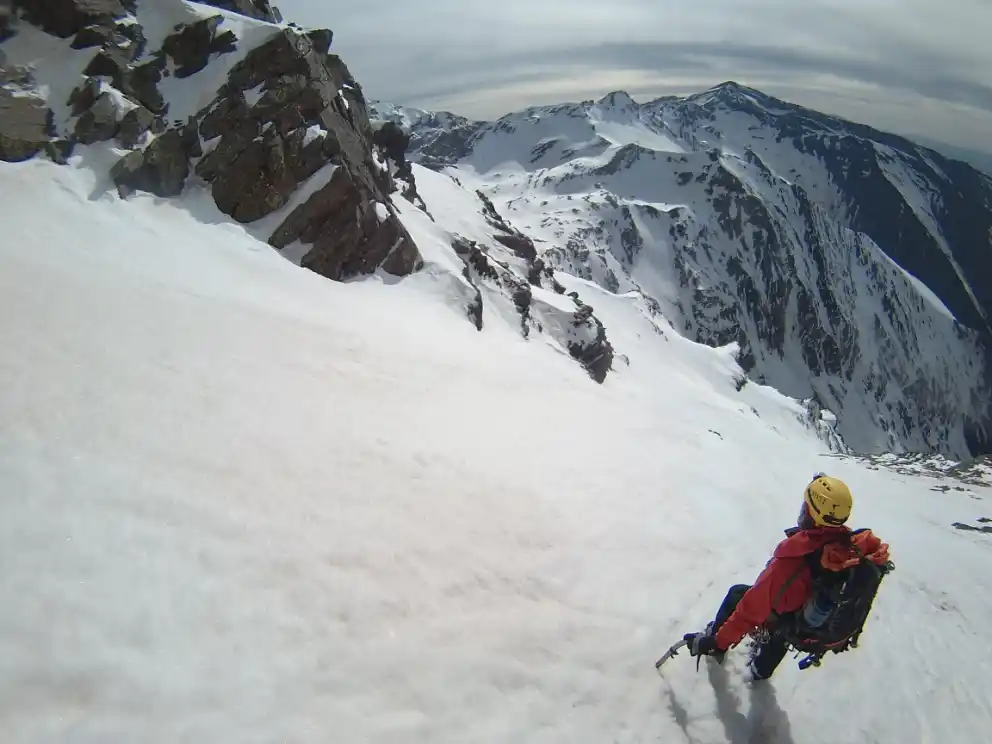
Under winter conditions, the most comfortable descent to the Valdecasillas starting from the Laguna de la Mosca is the one that goes through the small depression below the Juego de Bolos Peak. This depression is located to the west of the Laguna de la Mosca and, from there, you can descend to the Valdecasillas following a wide snow slope. This shovel, of moderate slope, ends in a narrow steep channel that we will be able to avoid on the right. Finally, leaving the Chorreras de la Mosca above, to our right, we will come out into the great valley through which the Valdecasillas River flows.

If conditions permit and we are confident enough, we can descend to the Valdecasillas from the Laguna de la Mosca more directly, distancing us less from the streams that are the drainage of the lagoon, the so-called Chorreras de la Mosca. This option will force us to cross narrower passes and closer to cliffs, which is why we will be forced to take extreme precautions.

Once we have overcome this complicated part of the descent, we will only have to continue descending along the Valdecasillas River and return to our bivouac area (point 7), where we will spend a second night.

 DAY 3: RIVER VALDECASILLAS – VEGUETA DEL CARACOL

The third day, after waking up from our bivouac (point 7), the only thing left to do is to retrace the path followed on the first day, a path that will take us about 4 hours, and that will allow us to return to the Vegueta del Caracol (point 0).

The tracks for GPS in general, and, in particular, registered in ravines, corridors, corners and other tight places, generally contain inaccuracies.

Most of the GPS reflect the graphic scale of the map in the screen. As we activate the zoom of the device, the scale of the map will vary. If we “get closer to the ground,” the scale of the map decreases, and, consequently, we see a smaller amount of “ground” than if we “get away” from it, that is to say, that we increase the scale of the map.

When you follow a downloaded and previously stored track in our GPS, we must ensure that the scale of the map on which the path appears is never too small. We will seek to “get away” from the floor, and we will not obsess with faithfully following the stored track , because we may not notice the inaccuracies that the latter contains.

The precision of the GPS is used to record the route was a, and the GPS that we are using for doing it is another, and therefore, it will be impossible that the points of both tracks, which serves us as a guide and that we are recording, match at 100%. It is for this reason that, even with a single way to move from a particular place, let us note that the track serves us guide runs several meters to the right or to the left of our location.

This website is translated into English. Please note that, in general, there may be a discrepancy between the Spanish and English versions, due to the translation process, and the interpretation that may exist in different countries of the specific terminology of the proposed activities. The Provincial Council of Granada advises the user to be careful when following the instructions on the site, and to consult an expert in case of doubt. The user is aware of the importance of carefully reading these warnings. The use of this website implies the full acceptance of the terms and conditions contained in this legal notice.

Responsibility

The Provincial council of Granada can not assume any liability arising out of the misuse, improper or unlawful use of the information displayed on the Internet page of www.exploregranada.es.

The Provincial council of Granada disclaims any liability resulting from the misuse of the content of its website and reserves the right to update, remove, and restrict or block access when deemed appropriate. It is recommended that each one of the users is responsible and prudent in the mountain. In any case, the user has to take the necessary precautions, for its use involves the exercise of a high-risk activity.

The Provincial council of Granada is not responsible for possible security errors that could be caused by the use of computers infected with viruses. Neither is responsible for the errors caused by the use of browsers with non-updated versions.

The Provincial council of Granada is not responsible for the information that is displayed on web pages outside connected directly or indirectly by links to the page www.exploregranada.es.

The elaboration of these reviews has required the previous realization of the specific activity.

All times described are effective and indicative, having taken into account for their calculation an average group of participants, an average capacity of these and the minimum stops for refreshments and rest.

The information contained in this Website is to effects indicative of tourist practice or sport.

In no case does it involve the organization by the Provincial Council of Granada of the activities described herein.

The properties through which the itineraries run are not owned by the Provincial Council of Granada.

Neither corresponds to the same its maintenance.

In any case, the user has to take the necessary precautions for its use involves the exercise of a high-risk activity.

The equipment, signaling, and any other type of installation on the route may also suffer unforeseen variations with the passage of time, for various reasons such as weather, deterioration, or vandalism; therefore it is strongly recommended to be accompanied by a guide if you do not know the terrain or the situation in which the signaling or equipment are located.

Also, we invite you to document yourselves with books and specialized guides to complement the information described on this website.

Pre-plan the activity. You should obtain reliable and proven information about the route and the activity that is intended to perform, in terms of the physical demands, technique, equipment necessary to make it, etc, In this “design phase” of the activity is where you can act on those elements that generate the risk that the activity entails.

Inform yourselves about the weather in the area. Do not forget that the weather in the mountain is very variable. Today, there are numerous possibilities of obtaining this information. This information is valuable to analyze, evaluate and assess the tolerability of these risks (rain, snow, storms, wind, etc.) which may be present or to accompany the activity. The paths may vary a lot depending on the time of the year and the weather conditions, therefore it is recommended to pay attention to the recommendations made in this regard and check the weather before each departure.

Each one of the participants of an activity must assess whether the weather is or not adverse to their own physical condition and skills to cope with this activity and it is your responsibility to do it or not.

Confirm in the area the prior information. Once you have arrived at the area of the activity to confirm the information previously acquired on the condition of the trails, roads, the snow conditions, weather, water level of the rivers, the situation of the sea to the specific activities that develop there, equipment that could have the sports facility, in case you need them, and dangers arising lately in the path and/or activity etc

This information can be confirmed in the information centers, mountain guides, shelters, Police, etc., The information contained in this website is based on optimal conditions and equipment in good condition to do the activity, and it is not the responsibility of the Provincial council of Granada the conditions of the sport equipment.

Adapt the activity to our physical conditions. Be modest and learn to resign. You have to know to renounce, even though one is very experienced. The mountain will always be there and will wait for us. Always put first the safety of the collective, second the safety of the individual. You should never be too self-confident or lessen your focus, no tter how easy the activity is. The physical ability is fundamental to the realization of any activity in the mountains, so there is no overvaluing our physical abilities, and we have to know how to adapt the paths to our terms. In case of not having sufficient capacity, users should refrain from doing the routes.

Adapt the activity to our technical conditions. For the carrying out of any activity in the mountain and more those that involve some risk, it is necessary to have knowledge of the specific techniques and necessary to carry them out; so we recommend people who do not have the necessary knowledge to refrain from performing any activity, even those that seem easier like hiking. The simple reading of the reviews contained in this website do not train any person for practicing the activity. It is always recommended the accompaniment of guides and staff specialized in the mountains.

Likewise, it requires a prior and deep understanding of the medium in which the activity is carried out, as well as the right time and the optimal conditions to carry it out.

Personal technical equipment. It is absolutely essential to bring the technical material, clothing, footwear, specific documentation, equipment, sun protection, food and water, etc., necessary to perform sports activities. If the activity is of high commitment, it should be expanded to first aid kit and emergency resources. The equipment must be perfectly revised and adjusted to the information and pre-planning.

Subjective objective risks inherent in all sport activities on the mountain. In all athletic activities on the mountain there is an evident exposure to falls with very serious consequences, which may be, but not limited to: brain Trauma, in limbs due to slipping on rocks, in the jumps without any visibility of the bottom, poor reception to the water in the jumps, assurance deficient in the descent of rappelling, extreme tiredness, excess of confidence, lack of preparation or equipment for the activity, inappropriate use of material, hypothermia, and dehydration.

This type of sporting activity involves risks that each participant must know and assume.

We must never underestimate risks and overestimate our capabilities.

It is possible that the fixed equipment the activity counts on (ravines, climbing, etc) and that depends on the progression and/or the protection against the fall in some sections, is not in good condition, as we do not have a regulated periodic maintenance. It is the responsibility of each user to see/check if the material is in good conditions and judge whether or not they can trust in it before you use it.

There are activities which develop in the snow, in places that are very exposed, or in the inside of a course of water, and depending on the time (during defrost, immediately after a snowfall, after a period of rain or storm), could dramatically increase the flow becoming very technical and dangerous. We must never underestimate risks and overestimate our capabilities.

This type of sporting activity involves risks that each participant must know and assume.

As well as an activity in the nature, there may be rock falls, landslides or trees, etc

Guides. In case you go with a guide, you must follow the instructions of the guides, coordinators, or people with more experience, preventing situations of risk, personal or groupal. It is necessary to put in the knowledge of the guides or companions of the activity any possible injury or incident which may affect the development of the activity before and during the athletic activity in nature.

The participants in the activities contained in this website must possess sufficient knowledge and the physical capacity which will enable you to make the specified activities, and to deal with them they must have sufficient capacity, technical and physical, so that they can do it independently and safely. Likewise, they assume the risks inherent in this type of activities and have the knowledge and the equipment needed to perform the activities, and must be approved by the U. E. and in optimum condition for your use.

Do not go alone to the mountain to perform the activity. If you do so, limit yourselves only to places with prior experience, known and consistent with your physical ability and technique. Except in exceptional circumstances, never to leave alone a member of the group, and much less if they're injured or fatigued.

Report on the activity and planned itinerary and respect what has been planned. Communicate to someone (shelter, camping, hotel, friends, relatives) the place and the activity to be performed. And importantly, even if sometimes it is cumbersome, it is imperative to warn that same person of the end of the activity. This recommendation is essential when trying to perform a solo activity.

Graduations. The participants of the activities should be trained to perform the activities in function of the graduation set for each activity, so it is your responsibility to know these rankings and the risks that it involves, therefore you assume performing the activity and everything that could happen.

Learn how to orient yourself. Carry GPS, mapping of the area and compass. You can not trust everything to the GPS, in certain situations it may fail. With a proper handling of the compass and map, we can reduce the risks and prevent accidents.

The tracks for GPS in general, and, in particular, registered in ravines, corridors, corners and other tight places, generally contain inaccuracies.

Most of the GPS reflect the graphic scale of the map in the screen. As we activate the zoom of the device, the scale of the map will vary. If we “get closer to the ground,” the scale of the map decreases, and, consequently, we see a smaller amount of “ground” than if we “get away” from it, that is to say, that we increase the scale of the map.

When you follow a downloaded and previously stored track in our GPS, we must ensure that the scale of the map on which the path appears is never too small. We will seek to “get away” from the floor, and we will not obsess with faithfully following the stored track , because we may not notice the inaccuracies that the latter contains.

The precision of the GPS is used to record the route is one, and the GPS that we are using for doing it is another, and therefore, it will be impossible that the points of both tracks which serves us as a guide and that we are recording, match at 100%. It is for this reason that, even when there is only one way to travel a particular location, let us note that the track that serves us as a guide runs several meters to the right or to the left of our location.

The activity in the mountains is not finished until we return to a safe place. The summit is only half of the journey. Do let your guard down until you're completely safe. This includes returning home in your car. There are too many mountain sports practitioners who have road accidents after a tough activity.

The digital mapping used in this website has been generated by the IGN (National Geographic Institute), to be used according to the conditions of the license of use and in accordance with the Ministerial Order FOM/2807/2015.

If there's any accident alert the emergency number, and even the family members or emergency contact. Every minute is important. To meet this recommendation is necessary to carry a mobile phone with charged batteries or any other means of communication to launch the alarm. The GPS is very useful to properly communicate our position and to facilitate our location. In Spain, the monst useful emergency phone numbers are 112 (Civil Protection), 062 (Civil Guard).

The Provincial council of Granada is not responsible for the correct or incorrect use which might be made of this summary, and the consequences that may arise from it. For this reason, it is recommended to the users to be responsible and prudent while carrying ouit the activities on this website. The use of these reviews implies the user will assume the inherent risks of the activity and involves the recognition of their sole responsibility for the security during the development of the activity. The simple reading of the reviews contained in this website do not train any person to practice the activity. It is always recommended to be accompaniment by guides and staff specialized in the mountains.

The various activities contained in this website, are part of what are considered to be risk sports, and they require learning and experience. This website provides technical information for many sport activities in nature, existing at present in the province of Granada, without managing to include, on occasions, information about the state of conservation and maintenance of the routes, facilities or equipment, if there's any. Therefore, the security contiditions for each and every proposed activity are not guaranteed.

The Provincial council of Granada does not assume in any case any responsibility for accidents that may occur while performing the activities listed here.

The information contained in this website is not intended to replace in any case, the experience of participating in sporting activities in the nature, who should be aware of the risks associated with the practice of these sports that are presented here and assume the responsibility to address these risks.

Some of the areas included in this guide are located within protected natural spaces subject to specific legislation and that the mountaineer should know beforehand.

The Provincial council of Granada does not assume in any case, the legal consequences of any infringements against the current legislation.

For any suggestion, the Provincial council of Granad invites you to send an email to the Contact from the web www.exploregranada.es.