Logo Turismo Granada Header

North of the Veleta

Climbing under summer and winter conditions on the northern slope of the Picacho del Veleta (3,398 m.a.s.l.), the second-highest summit in the Sierra Nevada.

Downloads

Alta Montaña

High Mountain

Alpinismo

Alpinism, Classic Climbing

Invierno

Winter, Spring

Technical data sheet

Technical Difficulty:

Very diverse, depending on the chosen route and the existing conditions (summer or winter). In any case, the technical difficulty of none of the routes is below the AD top. Before starting the route, in addition to the weather conditions (snow, rain, wind...), the risk of avalanches, the generalized existence of ice, etc., must be taken into account (consult here).

Length of the routes: 300 m.
Orientation: Northeast and east.
Equipment:

Self-protection ropes (classic climbing and mountaineering). Only occasionally will we find expansive anchors or pitons, as meetings or as intermediate safeties.

Details on the duration:

Time alignment distance: 2:30h.

Positive height gain accumulated: 976,00 m.
Minimum altitude: 2.509,00 m.
Maximum altitude: 3.398,00 m.
Departure point: Hoya de la Mora, Sierra Nevada (Monachil).
Point of arrival: Hoya de la Mora, Sierra Nevada (Monachil).
Closest/s Population/s : Pradollano, Sierra Nevada, Monachil).
Municipality/ies: Monachil and Güéjar-Sierra.
Region/s: Vega de Granada.
Natural Space/s: Natural park of Sierra Nevada - Las Alpujarras

Map & Profile

Mapa-Norte-Veleta-WEB
Map of the "North of the Veleta"

Full tour

Total distance: 10919 m

Waypoints

Point Name Time (*) Height Latitude (**) Length (**)
0 Hoya de la Mora (Hostels) 0:00 h. 2509 m. N37° 05' 40.1" W3° 23' 08.5"
1 Veredón 2:15 h. 3111 m. N37° 03' 58.9" W3° 22' 06.3"
2 Abseil 2:25 pm. 3165 m. N37° 03' 48.7" W3° 22' 05.2"
3 Corral del Veleta 2:30 h. 3080 m. N37° 03' 43.9" W3° 22' 03.5"
4 Veleta 0:00 h. 3398 m. N37° 03' 26.1" W3° 21' 52.3"
5 Track 0:15 h. 3160 m. N37° 03' 40.5" W3° 22' 13.7"
0 Hoya de la Mora (Hostels) 1:45 h. 2509 m. N37° 05' 40.1" W3° 23' 08.5"

(*) Approximate times counting stops.
(**) Geographic coordinates. European Datum 1.950.

Introduction

For the elaboration of this review, we have taken as a fundamental source of information what has been published in relation to the Veleta by CampoBase magazine in its issue 149 (December 2016). 

The approach to the northern slope of the Picacho del Veleta begins in the Hoya de La Mora (Albergues). Our path will always run close to the old Granada-La Alpujarra road, sometimes coinciding with it and sometimes cutting it. Once we reach the height of the Posiciones, we will descend to the Corral del Veleta through the Veredón, or rappelling, depending on the conditions. From the Corral we will begin to climb either the northeast wall or the east wall of the Veleta, depending on the route chosen. Once we finish climbing, we will descend through the west slope of the Picacho until we find the route of the old Granada-La Alpujarra road (a ski slope when the resort is open). Through the old road we will arrive at the height of the Posiciones, thus finding our way back to the Albergues.

On the walls that make up the northern, northeastern, and eastern slopes of the Veleta, some of the highest altitude climbs in the Iberian Peninsula take place. On the other hand, and in spite of this, access to the routes is relatively easy in terms of time and difficulty. Climbing in the Veleta always takes place above 3,000 meters of altitude, in a completely alpine environment that requires experience in high mountain.

The name Veleta comes from the Arabic "balata", which means balate, slash, cut. The name "picacho" is due to its prominence, being the most visible and identifiable summit of the Sierra Nevada when viewed from the city of Granada.

Description

DURATION:

Any of the routes that run through the walls to the northeast and east of the Vane can be made in 1 day.

DIFFICULTY:

Very high. These are demanding itineraries, and, as in any classic climbing or mountaineering activity, with a high exposure to falls with risk of injury or death. During the activity, it is essential to be free of vertigo and to master climbing techniques in general and, in particular, those of self-protection. Most of the climbing routes that run along the northern slope of the Veleta lack fixed equipment to protect against possible falls, so all of it must be installed, and subsequently removed, by the climbers. Under winter conditions it is not only necessary to master progression with crampons and an ice axe, and to know and have practiced self-arrest regularly, but it is absolutely essential to master mixed and ice climbing techniques. We should never overestimate our abilities. In case of doubt about them, it is recommended to hire a mountain guide.

WATER:

Under summer conditions we may find a snow pit in the Corral del Veleta from which to obtain water. Under winter conditions the only way to obtain water is by melting snow (only possible if you have a stove).

MATERIAL NEEDED:

Individual (generic): hiking boots (and gaiters in winter), warm clothing (hat, gloves -several pairs in winter-, fleece or similar, windbreaker...), waterproof jacket, neck tube, sunglasses (spare pair in winter), sunscreen and high protection lipstick, headlamp, pocket knife, lighter, cell phone (with spare charge), spare T-shirt, underwear and socks.

Solo climbing: helmet, climbing shoes (or crampons and one or two ice axes - depending on route and conditions - in winter), harness, two locking biners, descender, rope ring (for self-locking knot), lanyard (e.g.: locking biner and dynamic rope) and ice axes.

Collective (generic, for a team of 2-3 people): first-aid kit, map, compass and GPS (with spare batteries).

Collective for rock climbing (for two teams of 2-3 people): two 60 m. double ropes, assorted belay devices (4-5 medium and small friends and 6-7 small crackers, plus 2-3 ice screws, 1 stake, and 1 anchor in winter), 5-6 extra-flat non-deformable (hard) steel pitons, 12 sewn lanyards (10 of 60 cm. and 2 of 120 cm.) with their respective pairs of carabiners, and 6 safety carabiners and 2 sewn lanyards of 180 cm. for equalized anchor systems, and 1 pair of walkie-talkies.

BEST TIME/S:

Given that some routes are suitable for winter conditions, while others have a marked summer character, climbing on the north slope of the Veleta can be done during most of the year.

Summer is the best time for climbing under summer conditions, and autumn is very cold.

Winter and early spring are the ideal times for climbing in winter or near-winter conditions.

GUIDE (SKETCHES, ETC.):

Report "Especial Veleta", and proposal "Rutas invernales en el Veleta", published in the nº149 (December 2016) of CampoBase magazine.

MAPPING:

  • Sierra Nevada National park. The Alpujarra. Marquesado del Zenete. Scale 1:40.000. Editorial Penibética.
  • Topographic map of Slopes of the Sierra Nevada (Evaluator Risk of Avalanches). Scale 1:25,000. Editorial Vane.

LANDSCAPE, FLORA AND FAUNA:

High siliceous summits with glacial and periglacial forms.

In summer, around 2500 meters above sea level, the flora is composed of low brushes, bolinas of Sierra Nevada, rascaculos, lion skins, thyme of the mountains, white myrtles and creeping junipers. Crossing the Veredón, where the flora is already scarce, we will see the Sierra Nevada's romperrocas, zamárragas and cincoenrramas.

In the summer it is common to the sighting of wild goats.

 REMARKS:

The predominant type of climbing on the Veleta under summer conditions is on slabs, with short overhangs and very few cracks. Blunt hand holds are very common. Given the poor quality of the rock, and the scarcity of cracks, small hand holds will be the most commonly used.

The ice that occasionally repels the rocks will only allow us to place short screws, and only if the conditions are good and we are not faced with a thin "verglass".

In winter, it is the climbing trails located on the east wall that can present the best ice conditions. Those on the northeast slope will only present good ice conditions after the passage of wet fronts, or the precipitation of freezing rain, combined with winds from the north.

The schists, which are the predominant rock in the high snowy mountains, have very sharp edges that make the use of double ropes essential.

During the summer period, the journey between Hoya de la Mora (point 0) and the Posiciones del Veleta (Veredón, point 1), and vice versa, can be made using as means of transport the SIACthe Servicio de Interpretación de Altas Cumbres del Parque Nacional y Parque Natural de Sierra Nevada.

RULES TO RESPECT:

Summarized in a brief guide to environmental regulations applied to mountain sports in protected natural spaces of Andalusia (pages 52 and 53) and in the booklets General rules in the Natural area of Sierra Nevada, Responsible behavior in the National Park and Natural Park of Sierra Nevada, and Responsible behavior, Droppings, and debris of personal hygiene. More extended in the Decree 238/2011, 12 July, which establishes the organization and management of Sierra Nevada (points 5.4.5. –p. 163 - and 5.2. –page 262-).

WEATHER:

CONDITIONS OF THE ROUTES:

Before starting the climb, it is recommended to consult the conditions of the mountain range (risk of avalanches, general existence of ice...) through the following links:

How to arrive by car

From Granada we will go by the highway A-44 towards Motril. We will then take the exit 132 (Round South/Sierra Nevada/Alhambra/Health Campus) and, once in the Ronda Sur, we take the exit 5B (A-395/Sierra Nevada/Pinos Genil). From that moment, only we will follow the road A-395 towards Sierra Nevada without deviating at any time. Arriving at Pradollano (the urbanization of the ski resort), we will find a crossroads where the direction to follow towards the "Albergues/Hoya de la Mora" is indicated. We will take this detour (to the left) and we will follow at all times the signs that lead us to the Hoya de la Mora. Arrived at the Hoya de la Mora (point 0), we will see that there are two paved esplanades, and several wooden kiosks on both sides of the road. In one of the two esplanades we will find the parking.

On weekends (Saturdays, Sundays and holidays) during the ski season (end of November-May), it is only possible to park in Hoya de la Mora (point 0), in the available places, and if you arrive before 8:00 a.m. (this rule could change). However, as an alternative, we have the Parking Los Peñones of the the ski resort (for a fee), which can be accessed through the detour “C. A. R. D./PRADOLLANO”, located 2 km before reaching the Hoya de la Mora. Once parked our vehicle in the Parking Los Peñones, we would take the urban bus of Sierra Nevada to access the Hoya de la Mora/Albergue Universitario (also to get to our vehicle at the end of the activity), which has the following hours.

Parking

Available.
Parking exit:

Hoya de la Mora, Sierra Nevada (Monachil).
https://goo.gl/maps/PacH42EewwWSaBPJA

Parking arrival:

Parking The Rocks, Sierra Nevada, Monachil).
https://goo.gl/maps/nVJTxLQXDF1BTXGM7

How to get there by public transport

The buses depart from the Bus station in Granada (platform 3) in the direction of Pradollano they do so with the following hours. Once in Pradollano, we will go to the bus stop, city of Sierra Nevada that is part of the same in the direction of the Hoya de la Mora (point 0, Albergue Universitario)only during the ski season (late November-may) and with the following hours. Outside of the ski season (may-late November), once we get to Pradollano, we will have to resort to any of the transportation services available to take us to the Hoya de la Mora, and we pick up after the activity. Once we are back in Pradollano, buses departing to Granada have different hours according to the time of the year.

Route

For more complete and detailed information on the climbing routes that run along the northern slope of the Veleta, we recommend consulting the "Veleta Special" published by CampoBase magazine in December 2016 (No. 149), a publication from which we have obtained, and with which we have contrasted, much of the information set out below.

APPROXIMATION

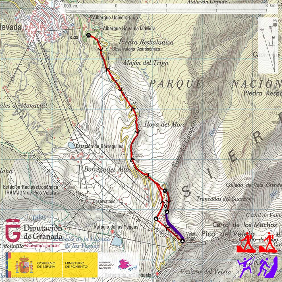
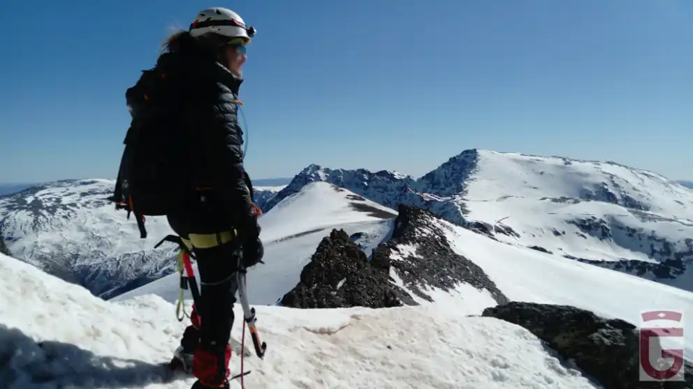
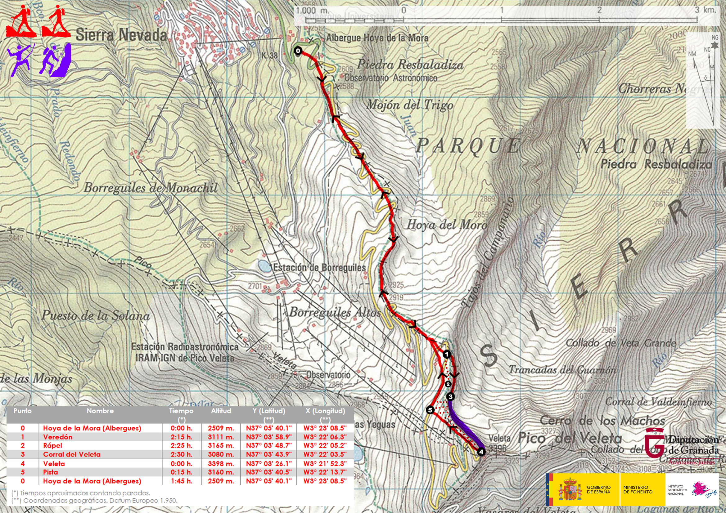
The approach to the north of the Vane begins in the Hoya de la Mora (point 0), also known as Los Albergues, due to the existence there of two lodgings of this type: the university and the military, the latter called Capitán Cobo.

From Los Albergues we will depart to the south, in an ascending direction following the alternating section of lane and trail that will permit us to cut through what will be our way through the old Granada-Alpujarra road, which zigzags over Loma del Veleta. The existence of snow may cause the disappearance of both lanes and trails, so the way we should go will be marked by the skiing tracks, along whose left margin we will transit

Camino del Veleta tras partir de la Hoya de la Mora (punto 0)
Camino del Veleta after departing from Hoya de la Mora (point 0)

After about 2 and a quarter hours from our departure, we will arrive at the height of the Posiciones del Veleta, a former rectangular construction, and some ditches, which constitute the remains of an entrenchment occupied by the "national" forces during the Civil War.

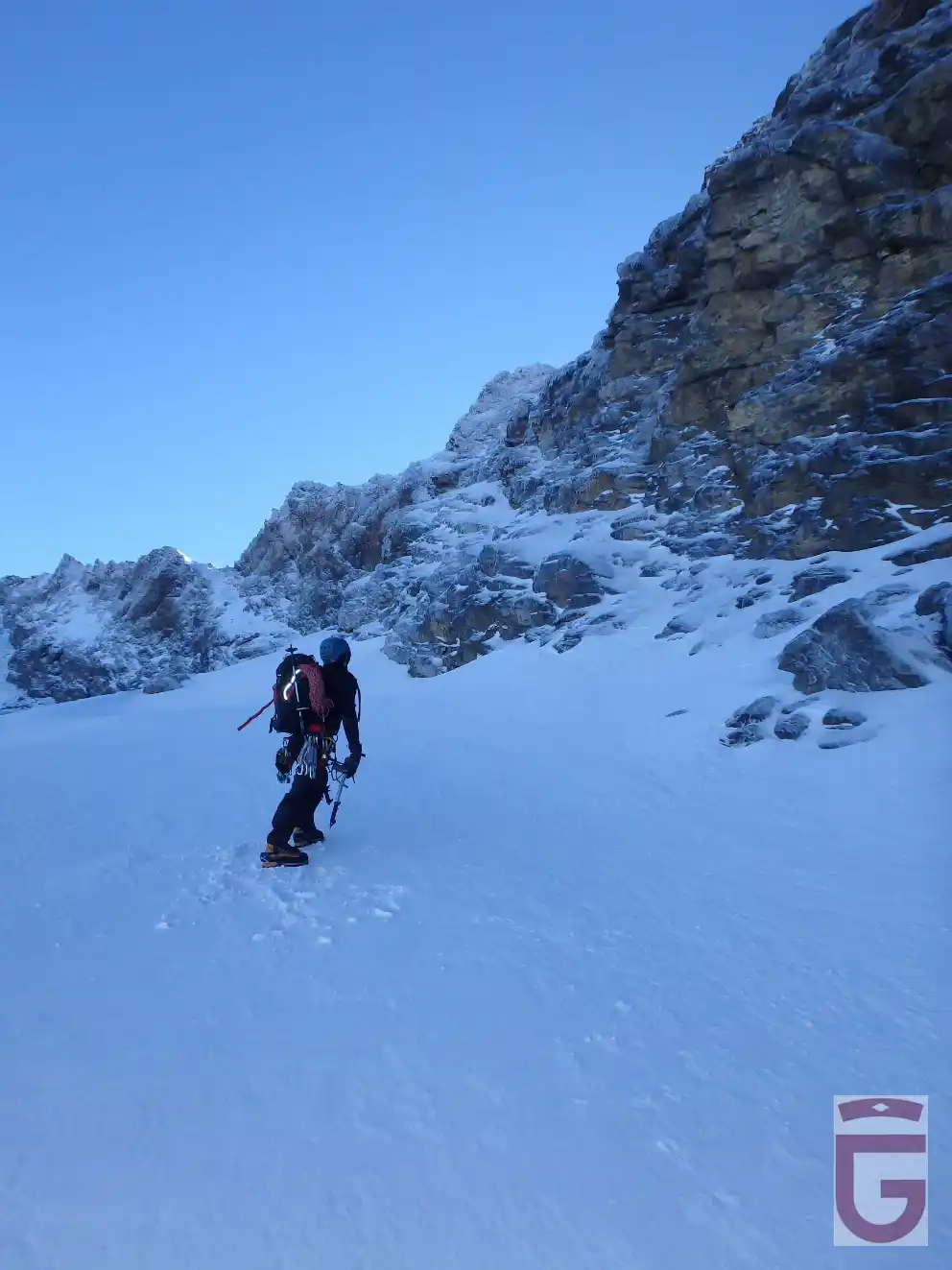
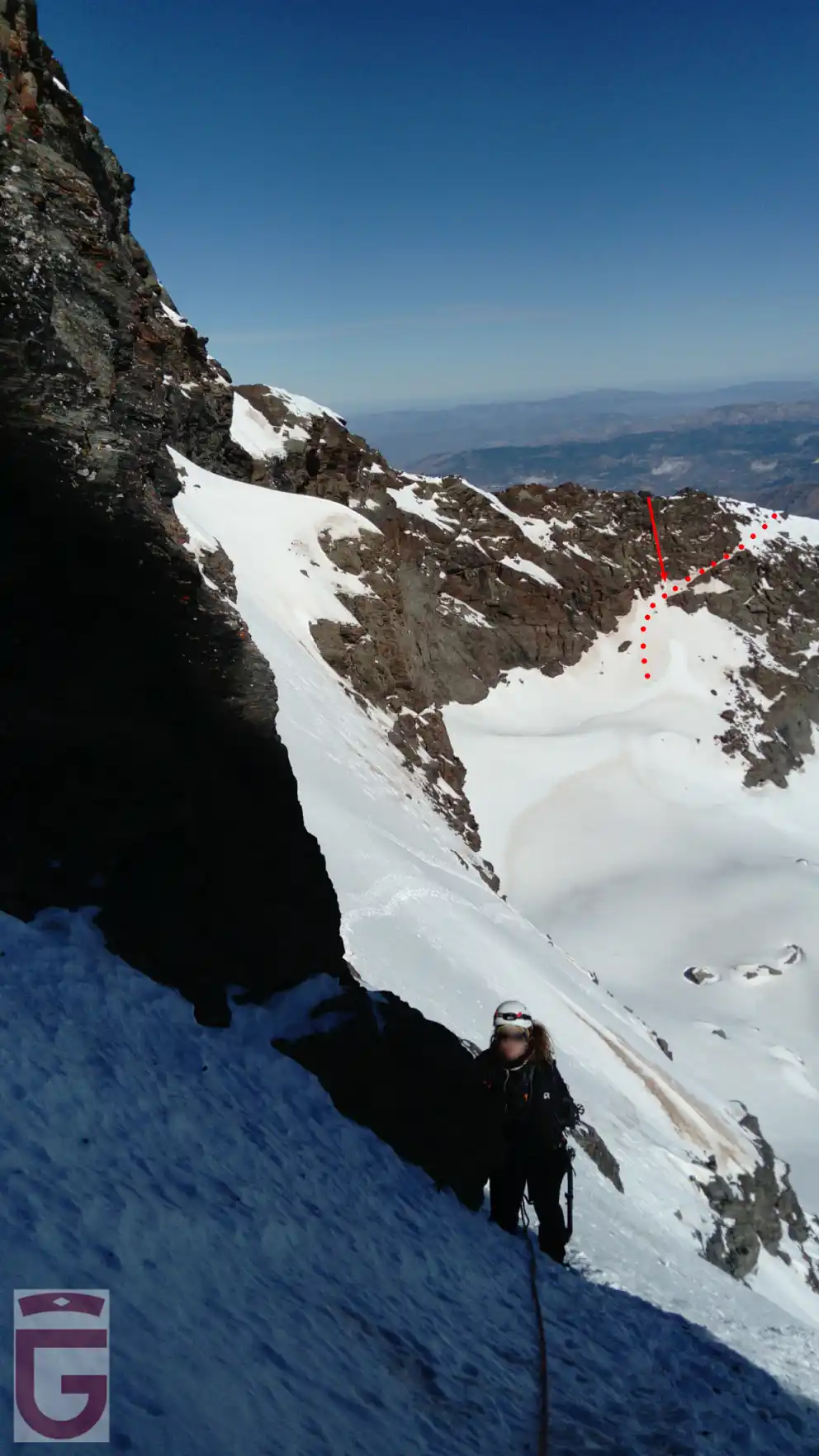
Leaving Las Posiciones behind, we will reach the start of the Veredón. (point 1, a trail that travels obliquely through the Tajos del Campanario leaning on a ledge, and which will allow us to descend to Corral del Veleta(punto 3), the basin of glacial origins that, supported by a moraine, is located at the foot of the northern slope of the Picacho

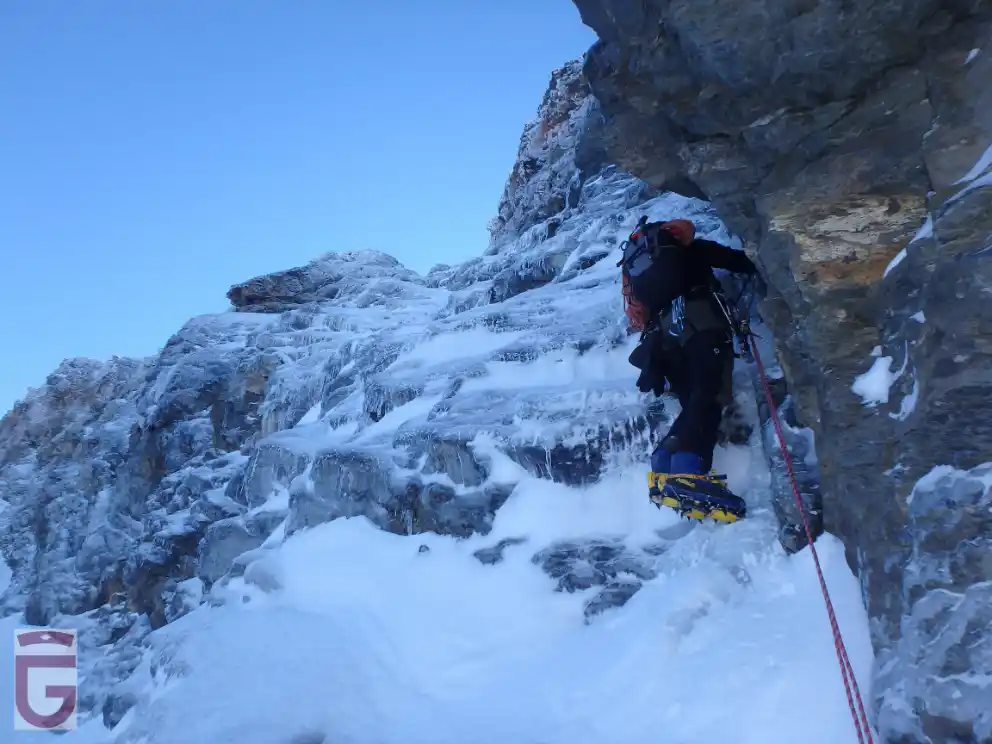
Under winter conditions, the Veredón will appear clear if there's little snow so, if there's no ice, it can be descended without much problem. However, if the snow is abundant, the Veredón will be hidden under a very steep snowy slope, a circumstance that will be aggravated if there's ice instead of snow. In this case it is advisable to avoid the hillside, very exposed, and use the installation for abseiling (point 2) that exists a little above the Varedón, behind an obvious gendarme and that, after 50 or 60 meters of descend (depending on its condition), will drop us above the Corral (be careful! With ice or hard snow it will be essential to secure ourselves to the slope before releasing the ropes).

Descendiendo hacia el Corral del Veleta siguiendo el Veredón (condiciones invernales). La vertiente norte del Veleta al fondo
Descending to the Corral del Veleta following the Veredón
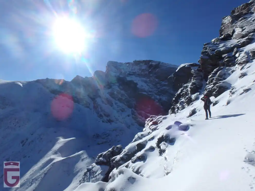
(winter conditions). The northern slope of the Veleta in the background
Descendiendo hacia el Corral del Veleta empleando la instalación para rápel (bajo condiciones invernales, con hielo y nieve helada).
Descending into the Corral del Veleta using the installation for abseiling
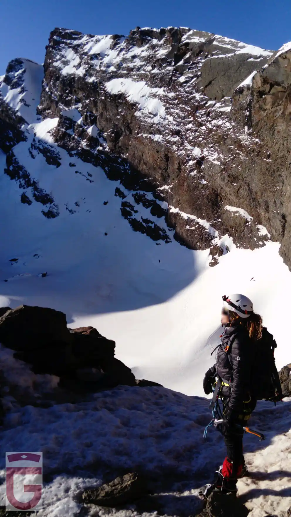
(under winter conditions with ice and frosted snow).

CLIMBING IN SUMMER

The descent to the Corral del Veleta (point 3), under summer conditions, that is to say, without snow, will be done by comfortably following the Veredón.

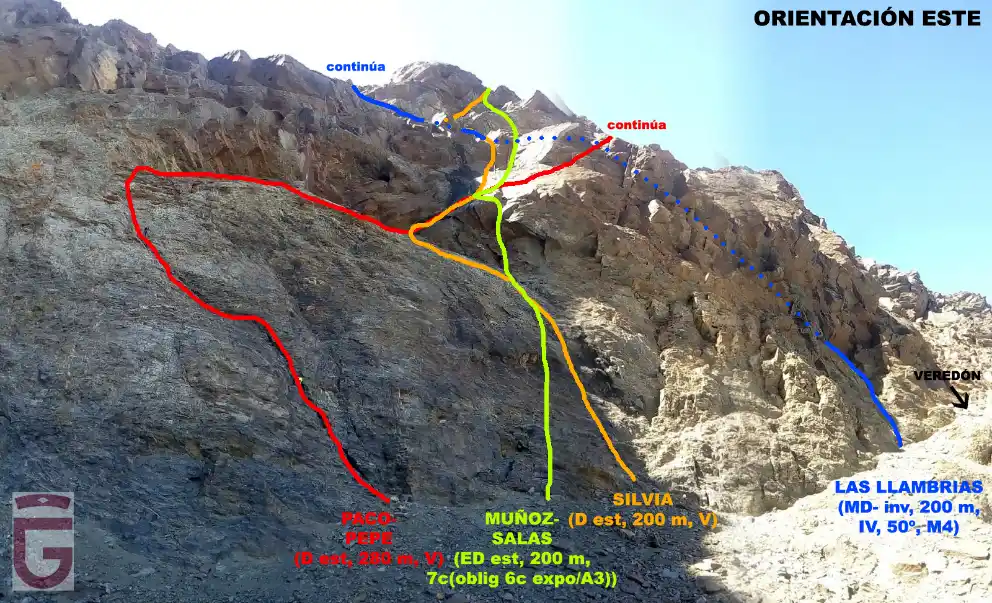
Once descended the Veredón the first thing we will find on our left will be the east wall, continuation of the north wall of the Veleta. On this wall we will point out two climbing routes eminently summery: the Silvia and the Paco-Pepe.

The Silvia (D, 200 m, V), with 5 pitches, is the most repeated summer itinerary of the north of the Veleta, due to its moderate difficulty and the great quality of the rock.

The most difficult step of the Silvia is located at the first pitch: a plated Vº degree step protected with a parabolt. Already in the second pitch, we will find the “step of the lizard” (V), crossing a narrow ledge that, contrary to what might seem to be by its name, is more simple to overcome “from the outside” (with good grips for the hands on the ledge and feet in adhesion).

In the third pitch, we will find a nice dihedral (V) protected with two pins.

Surpassed the third pitch, already high on the wall, the difficulties decrease.

In all the meetings of the Silvia will find one or two bolts.

The Paco-Pepe (D, 280 m, V), with 7 pitches, is, along with the Silvia, another of the popular trails of the Veleta due to its low technical difficulty.

The first two pitches of the Paco-Pepe follow a clear diagonal veer to the left to (IV) hat avoids the difficulties of climbing in plate and in collapse of the beginnings of the Silvia and the Muñoz-Salas respectively.

Once we have passed the left vira, we will make a right traverse, under an overhang, and on a platform, to finish overcoming the "paso del lagarto" (V) and reach the second meeting of the Silvia (third and fourth pitches).

The fifth and sixth pitches of the Paco-Pepe continue diagonally, with a tendency to the right, and cross the "great llambría" of the Veleta to then return to the vertical following a channel. From there the route runs diagonally, now to the left, and through simple terrain (IV), until leaving the wall.

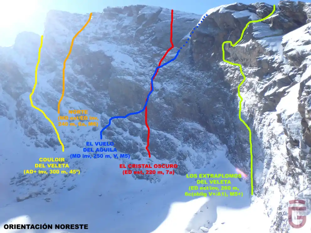
To the left of the Paco-Pepe route, oriented to the northeast, we will find other great summer classics of greater difficulty: Los Extraplomos del Veleta and El Cristal Oscuro among them.

Vías de escalada orientadas al este (bajo condiciones estivales)
East-facing climbing routes
(under summer conditions).

WINTER CLIMBING

Vías de escalada orientadas al noreste  (bajo condiciones invernales)
Climbing oriented to the northeast
(under winter conditions)

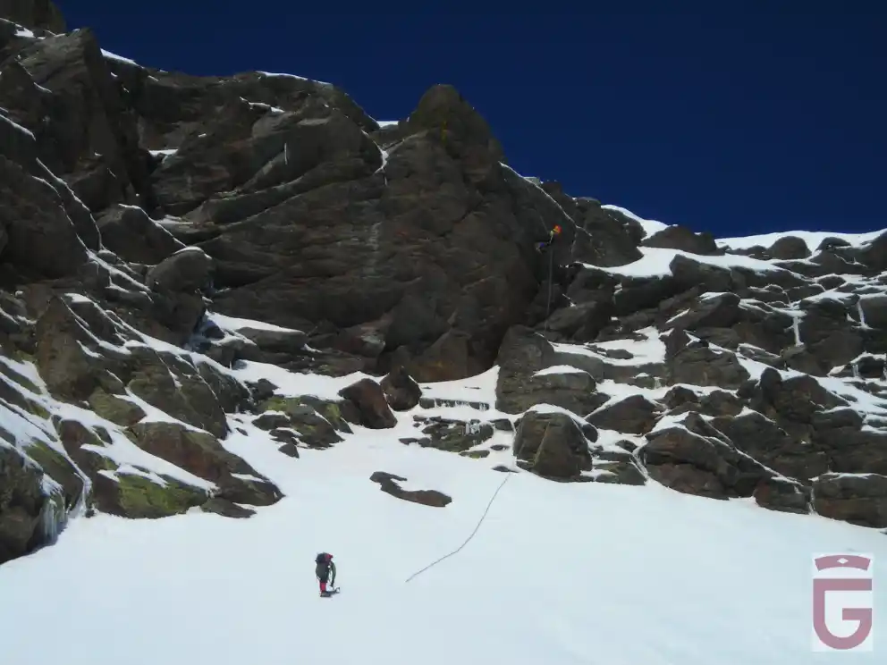
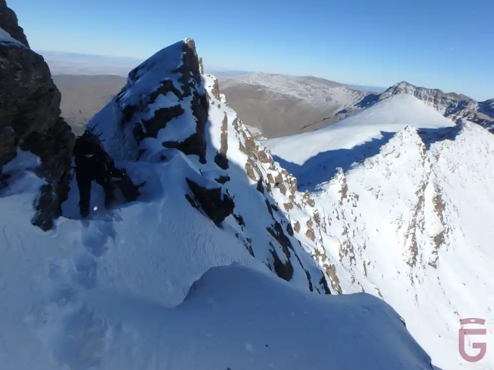
The Couloir del Veleta, or, simply, the Couloir, for its aesthetics, its proximity, and its affordable difficulty, is one of the most popular winter routes in Sierra Nevada.

Their technical difficulties (AD+, 300 m, 45º), which should never be underestimated (as it depends a lot on the conditions, which are very changeable), lies mainly in the access traverse to the snow corridor and in the exit to the summit via the Fidel-Fierro route (III+) of the south face.

The diagonal traverse that gives access to the corridor can be done through two traverses or ledges: an upper one, narrower, and a lower one, wider; it is highly recommended to do it through the latter, which is less exposed, although this decision forces us to climb a short final wall before starting the ascent through the corridor.

Couloir. Emprendiendo la travesía hacia el corredor siguiendo la vira inferior
Couloir. Embarking on the journey into the corridor, following the turns below
: Couloir. Superando el corto muro situado bajo el corredor, una vez finalizada la travesía por la vira inferior (condiciones mixtas)
Couloir. Overcoming the short wall under the corridor, after the crossing of the lower vira (mixed conditions).
En el inicio del Couloir. Veredón y rápel al fondo
At the start of the Couloir. Large sidewalk and rappel to the bottom
En la parte alta del Couloir
At the top of the Couloir

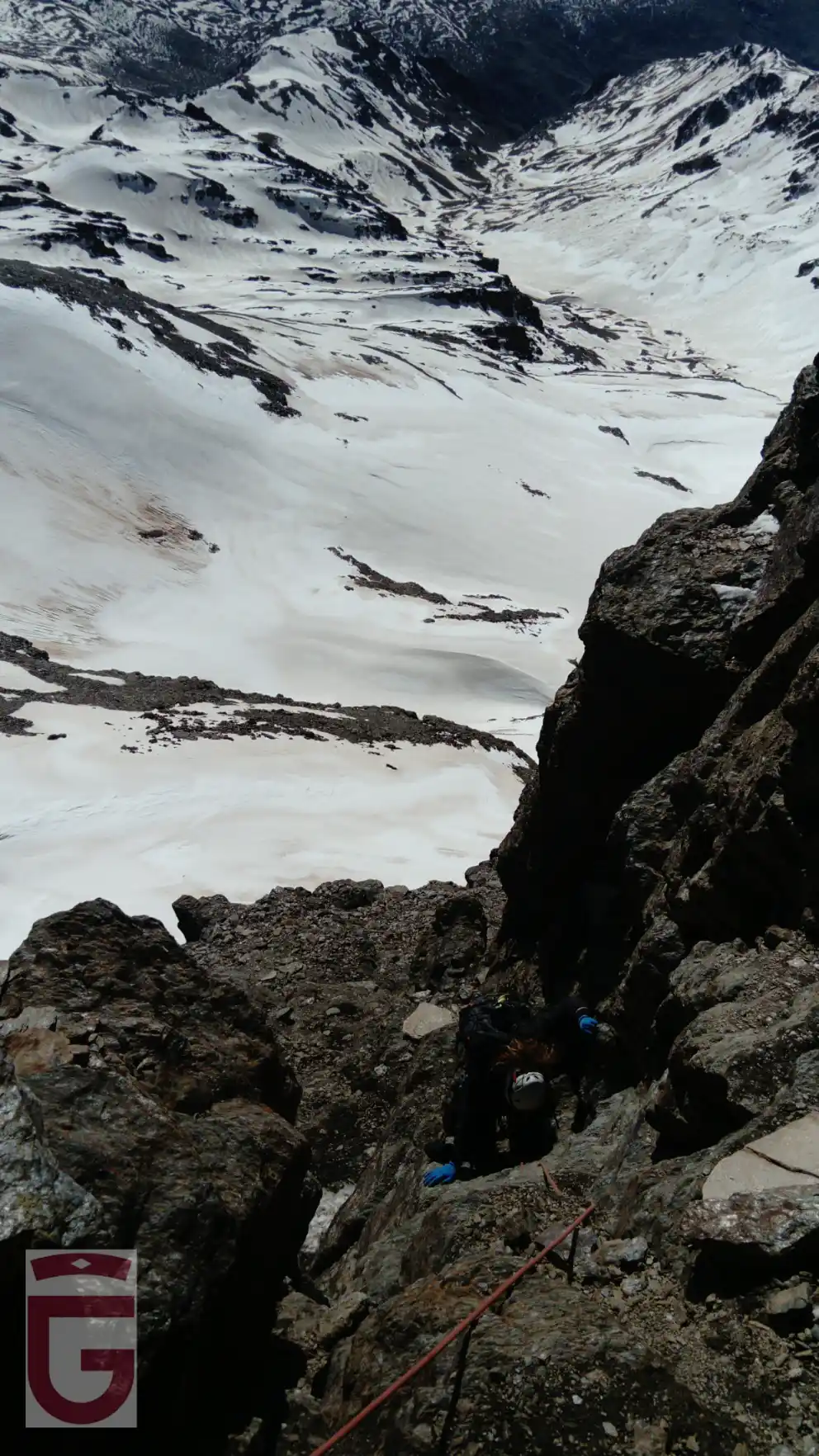
When we reach the top of the snow corridor (45º) we will have views over the valley of the Veleta River, which rises at the foot of the south face of the Picacho to join the Naute, a tributary of the Poqueira.

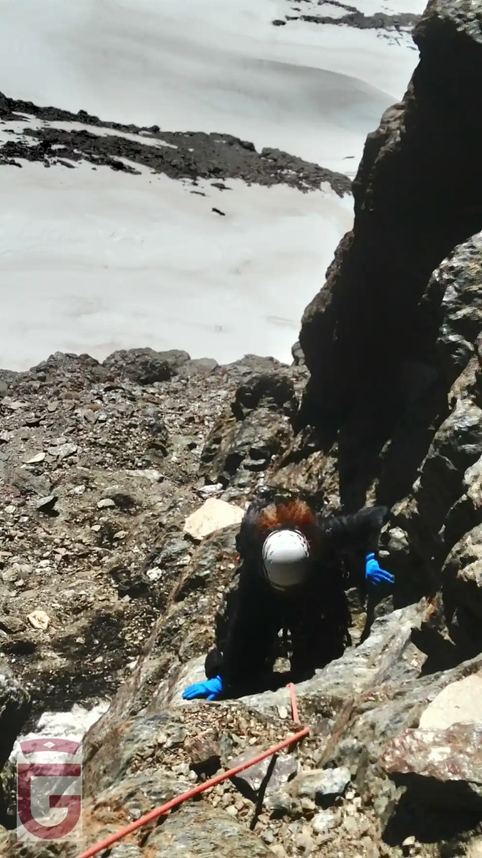
A right-hand ledge will allow us to traverse horizontally along the south face of the Veleta until we reach the base of a short wall that constitutes the beginning of the Fidel-Fierro route.

Once we have passed the wall, we will go through an ascending turn, to the right, until we reach the base of a wide chimney, which we will climb going out from it to an upper ledge. Traversing the ledge to the right or to the left, we will face the vertical, overcoming a last climb, and directly reaching the geodesic vertex of the Veleta (point 4).

If there is snow on the south face of the Veleta, this, due to the orientation, is usually of the "spring" type.

Couloir. Saliendo del corredor y comenzando a recorrer la repisa de la cara sur
Couloir. Leaving the corridor and starting to walk along the ledge of the south face

Fidel-Fierro. Superando la chimenea (condiciones secas)
Fidel-Fierro. Overcoming the chimney (dry conditions)
Vistas hacia el este desde la cara sur del Veleta. Arista Salón-Campanario-Zacatín en primer término, Cerro de los Machos detrás, y Puntal de la Caldera, Alcazaba y Mulhacén al fondo.
Views to the east from the south face of the Veleta. Salón-Campanario-Zacatín ridge in the foreground, Cerro de los Machos behind, and Puntal de la Caldera, Alcazaba and Mulhacén in the background.

In addition to the Couloir, but oriented to the east, we will find another route of moderate difficulty that, with good ice conditions, becomes an interesting winter itinerary. This is Las Llambrias.

The Llambrías of the Veleta (MD-, 200 m, IV, 50th, M4), con 4 largos, discurre a través del sistema de llambrías (placas tumbadas) que, en diagonal (de abajo a arriba, y de derecha a izquierda), recorren el sector este de la pared del Veleta.

The first pitch of Las Llambrías runs through the first inclined planes of this system, separated from each other by a traverse (protected by a parabolt) and by a narrow funnel. Once on the upper plate of this first pitch, we can protect the climb with short ice screws (if the ice layer is stable and sufficient), or by using some of the existing parabolts on the right wall.

The second pitch runs over the "great llambría" of the Veleta, a plate on which rests in winter a large hanging snowfield that is traversed diagonally.

The third pitch, in traverse (first ascending and then descending), crosses the fourth pitch of the Silvia and takes us to the step that, once overcome (with the help of a parabolt), leads to the upper slabs. Once this difficulty has been overcome, the route seeks the vertical through ice and rock projections and moderately steep snow ramps.

A logical alternative to exit The Llambrías, especially if the step that gives access to the upper plates is not in good condition, consists of climbing the last over of the Silvia to leave for her from the wall.

Other routes of marked winter character of the Veleta, although more difficult than those described above, are the North and the Vuelo del Águila.

RETURN

The climb will end at the summit (point 4) or, in any case, on the western slope of the Veleta.

Descending through the western slope of the Veleta we will soon reach the route of the old Granada-Alpujarra road: an unpaved lane in summer and a ski slope in winter (point 5). Following this route in a descending direction, we will soon reach the vicinity of the Posiciones del Veleta, from where we will only have to undo the path we took during the approach to end up returning to the Hoya de la Mora (point 0).

The tracks for GPS in general, and, in particular, registered in ravines, corridors, corners and other tight places, generally contain inaccuracies.

Most of the GPS reflect the graphic scale of the map in the screen. As we activate the zoom of the device, the scale of the map will vary. If we “get closer to the ground,” the scale of the map decreases, and, consequently, we see a smaller amount of “ground” than if we “get away” from it, that is to say, that we increase the scale of the map.

When you follow a downloaded and previously stored track in our GPS, we must ensure that the scale of the map on which the path appears is never too small. We will seek to “get away” from the floor, and we will not obsess with faithfully following the stored track , because we may not notice the inaccuracies that the latter contains.

The precision of the GPS is used to record the route was a, and the GPS that we are using for doing it is another, and therefore, it will be impossible that the points of both tracks, which serves us as a guide and that we are recording, match at 100%. It is for this reason that, even with a single way to move from a particular place, let us note that the track serves us guide runs several meters to the right or to the left of our location.

This website is translated into English. Please note that, in general, there may be a discrepancy between the Spanish and English versions, due to the translation process, and the interpretation that may exist in different countries of the specific terminology of the proposed activities. The Provincial Council of Granada advises the user to be careful when following the instructions on the site, and to consult an expert in case of doubt. The user is aware of the importance of carefully reading these warnings. The use of this website implies the full acceptance of the terms and conditions contained in this legal notice.

Responsibility

The Provincial council of Granada can not assume any liability arising out of the misuse, improper or unlawful use of the information displayed on the Internet page of www.exploregranada.es.

The Provincial council of Granada disclaims any liability resulting from the misuse of the content of its website and reserves the right to update, remove, and restrict or block access when deemed appropriate. It is recommended that each one of the users is responsible and prudent in the mountain. In any case, the user has to take the necessary precautions, for its use involves the exercise of a high-risk activity.

The Provincial council of Granada is not responsible for possible security errors that could be caused by the use of computers infected with viruses. Neither is responsible for the errors caused by the use of browsers with non-updated versions.

The Provincial council of Granada is not responsible for the information that is displayed on web pages outside connected directly or indirectly by links to the page www.exploregranada.es.

The elaboration of these reviews has required the previous realization of the specific activity.

All times described are effective and indicative, having taken into account for their calculation an average group of participants, an average capacity of these and the minimum stops for refreshments and rest.

The information contained in this Website is to effects indicative of tourist practice or sport.

In no case does it involve the organization by the Provincial Council of Granada of the activities described herein.

The properties through which the itineraries run are not owned by the Provincial Council of Granada.

Neither corresponds to the same its maintenance.

In any case, the user has to take the necessary precautions for its use involves the exercise of a high-risk activity.

The equipment, signaling, and any other type of installation on the route may also suffer unforeseen variations with the passage of time, for various reasons such as weather, deterioration, or vandalism; therefore it is strongly recommended to be accompanied by a guide if you do not know the terrain or the situation in which the signaling or equipment are located.

Also, we invite you to document yourselves with books and specialized guides to complement the information described on this website.

Pre-plan the activity. You should obtain reliable and proven information about the route and the activity that is intended to perform, in terms of the physical demands, technique, equipment necessary to make it, etc, In this “design phase” of the activity is where you can act on those elements that generate the risk that the activity entails.

Inform yourselves about the weather in the area. Do not forget that the weather in the mountain is very variable. Today, there are numerous possibilities of obtaining this information. This information is valuable to analyze, evaluate and assess the tolerability of these risks (rain, snow, storms, wind, etc.) which may be present or to accompany the activity. The paths may vary a lot depending on the time of the year and the weather conditions, therefore it is recommended to pay attention to the recommendations made in this regard and check the weather before each departure.

Each one of the participants of an activity must assess whether the weather is or not adverse to their own physical condition and skills to cope with this activity and it is your responsibility to do it or not.

Confirm in the area the prior information. Once you have arrived at the area of the activity to confirm the information previously acquired on the condition of the trails, roads, the snow conditions, weather, water level of the rivers, the situation of the sea to the specific activities that develop there, equipment that could have the sports facility, in case you need them, and dangers arising lately in the path and/or activity etc

This information can be confirmed in the information centers, mountain guides, shelters, Police, etc., The information contained in this website is based on optimal conditions and equipment in good condition to do the activity, and it is not the responsibility of the Provincial council of Granada the conditions of the sport equipment.

Adapt the activity to our physical conditions. Be modest and learn to resign. You have to know to renounce, even though one is very experienced. The mountain will always be there and will wait for us. Always put first the safety of the collective, second the safety of the individual. You should never be too self-confident or lessen your focus, no tter how easy the activity is. The physical ability is fundamental to the realization of any activity in the mountains, so there is no overvaluing our physical abilities, and we have to know how to adapt the paths to our terms. In case of not having sufficient capacity, users should refrain from doing the routes.

Adapt the activity to our technical conditions. For the carrying out of any activity in the mountain and more those that involve some risk, it is necessary to have knowledge of the specific techniques and necessary to carry them out; so we recommend people who do not have the necessary knowledge to refrain from performing any activity, even those that seem easier like hiking. The simple reading of the reviews contained in this website do not train any person for practicing the activity. It is always recommended the accompaniment of guides and staff specialized in the mountains.

Likewise, it requires a prior and deep understanding of the medium in which the activity is carried out, as well as the right time and the optimal conditions to carry it out.

Personal technical equipment. It is absolutely essential to bring the technical material, clothing, footwear, specific documentation, equipment, sun protection, food and water, etc., necessary to perform sports activities. If the activity is of high commitment, it should be expanded to first aid kit and emergency resources. The equipment must be perfectly revised and adjusted to the information and pre-planning.

Subjective objective risks inherent in all sport activities on the mountain. In all athletic activities on the mountain there is an evident exposure to falls with very serious consequences, which may be, but not limited to: brain Trauma, in limbs due to slipping on rocks, in the jumps without any visibility of the bottom, poor reception to the water in the jumps, assurance deficient in the descent of rappelling, extreme tiredness, excess of confidence, lack of preparation or equipment for the activity, inappropriate use of material, hypothermia, and dehydration.

This type of sporting activity involves risks that each participant must know and assume.

We must never underestimate risks and overestimate our capabilities.

It is possible that the fixed equipment the activity counts on (ravines, climbing, etc) and that depends on the progression and/or the protection against the fall in some sections, is not in good condition, as we do not have a regulated periodic maintenance. It is the responsibility of each user to see/check if the material is in good conditions and judge whether or not they can trust in it before you use it.

There are activities which develop in the snow, in places that are very exposed, or in the inside of a course of water, and depending on the time (during defrost, immediately after a snowfall, after a period of rain or storm), could dramatically increase the flow becoming very technical and dangerous. We must never underestimate risks and overestimate our capabilities.

This type of sporting activity involves risks that each participant must know and assume.

As well as an activity in the nature, there may be rock falls, landslides or trees, etc

Guides. In case you go with a guide, you must follow the instructions of the guides, coordinators, or people with more experience, preventing situations of risk, personal or groupal. It is necessary to put in the knowledge of the guides or companions of the activity any possible injury or incident which may affect the development of the activity before and during the athletic activity in nature.

The participants in the activities contained in this website must possess sufficient knowledge and the physical capacity which will enable you to make the specified activities, and to deal with them they must have sufficient capacity, technical and physical, so that they can do it independently and safely. Likewise, they assume the risks inherent in this type of activities and have the knowledge and the equipment needed to perform the activities, and must be approved by the U. E. and in optimum condition for your use.

Do not go alone to the mountain to perform the activity. If you do so, limit yourselves only to places with prior experience, known and consistent with your physical ability and technique. Except in exceptional circumstances, never to leave alone a member of the group, and much less if they're injured or fatigued.

Report on the activity and planned itinerary and respect what has been planned. Communicate to someone (shelter, camping, hotel, friends, relatives) the place and the activity to be performed. And importantly, even if sometimes it is cumbersome, it is imperative to warn that same person of the end of the activity. This recommendation is essential when trying to perform a solo activity.

Graduations. The participants of the activities should be trained to perform the activities in function of the graduation set for each activity, so it is your responsibility to know these rankings and the risks that it involves, therefore you assume performing the activity and everything that could happen.

Learn how to orient yourself. Carry GPS, mapping of the area and compass. You can not trust everything to the GPS, in certain situations it may fail. With a proper handling of the compass and map, we can reduce the risks and prevent accidents.

The tracks for GPS in general, and, in particular, registered in ravines, corridors, corners and other tight places, generally contain inaccuracies.

Most of the GPS reflect the graphic scale of the map in the screen. As we activate the zoom of the device, the scale of the map will vary. If we “get closer to the ground,” the scale of the map decreases, and, consequently, we see a smaller amount of “ground” than if we “get away” from it, that is to say, that we increase the scale of the map.

When you follow a downloaded and previously stored track in our GPS, we must ensure that the scale of the map on which the path appears is never too small. We will seek to “get away” from the floor, and we will not obsess with faithfully following the stored track , because we may not notice the inaccuracies that the latter contains.

The precision of the GPS is used to record the route is one, and the GPS that we are using for doing it is another, and therefore, it will be impossible that the points of both tracks which serves us as a guide and that we are recording, match at 100%. It is for this reason that, even when there is only one way to travel a particular location, let us note that the track that serves us as a guide runs several meters to the right or to the left of our location.

The activity in the mountains is not finished until we return to a safe place. The summit is only half of the journey. Do let your guard down until you're completely safe. This includes returning home in your car. There are too many mountain sports practitioners who have road accidents after a tough activity.

The digital mapping used in this website has been generated by the IGN (National Geographic Institute), to be used according to the conditions of the license of use and in accordance with the Ministerial Order FOM/2807/2015.

If there's any accident alert the emergency number, and even the family members or emergency contact. Every minute is important. To meet this recommendation is necessary to carry a mobile phone with charged batteries or any other means of communication to launch the alarm. The GPS is very useful to properly communicate our position and to facilitate our location. In Spain, the monst useful emergency phone numbers are 112 (Civil Protection), 062 (Civil Guard).

The Provincial council of Granada is not responsible for the correct or incorrect use which might be made of this summary, and the consequences that may arise from it. For this reason, it is recommended to the users to be responsible and prudent while carrying ouit the activities on this website. The use of these reviews implies the user will assume the inherent risks of the activity and involves the recognition of their sole responsibility for the security during the development of the activity. The simple reading of the reviews contained in this website do not train any person to practice the activity. It is always recommended to be accompaniment by guides and staff specialized in the mountains.

The various activities contained in this website, are part of what are considered to be risk sports, and they require learning and experience. This website provides technical information for many sport activities in nature, existing at present in the province of Granada, without managing to include, on occasions, information about the state of conservation and maintenance of the routes, facilities or equipment, if there's any. Therefore, the security contiditions for each and every proposed activity are not guaranteed.

The Provincial council of Granada does not assume in any case any responsibility for accidents that may occur while performing the activities listed here.

The information contained in this website is not intended to replace in any case, the experience of participating in sporting activities in the nature, who should be aware of the risks associated with the practice of these sports that are presented here and assume the responsibility to address these risks.

Some of the areas included in this guide are located within protected natural spaces subject to specific legislation and that the mountaineer should know beforehand.

The Provincial council of Granada does not assume in any case, the legal consequences of any infringements against the current legislation.

For any suggestion, the Provincial council of Granad invites you to send an email to the Contact from the web www.exploregranada.es.